It’s time we did something useful with Colombo Street so that transport objectives outlined in the city’s guiding central city planning document, An Accessible City (AAC), can be met. There’s only one useful thing to do and that is close Colombo Street somewhere. Below I’ll tell you where, and why.
AAC says (on page 5):
Routes will be prioritised for various modes of transport to provide efficient and safe access to and from the central city. This incorporates a road use hierarchy approach that identifies different preferred routes to access the central city depending on how people choose to travel.
For that reason, all transport corridors in our CBD have priorities assigned to them for four different transport modes: cycling, car travel, walking, and public transport. Many corridors have priorities for more than one transport mode assigned, which is fine. Two corridors have priorities for all four modes (all of Victoria Street and parts of Tuam Street), which doesn’t make any sense to me whatsoever. But apart from that detail, this prioritisation does make good sense and helps guide how we do rebuild our streets.
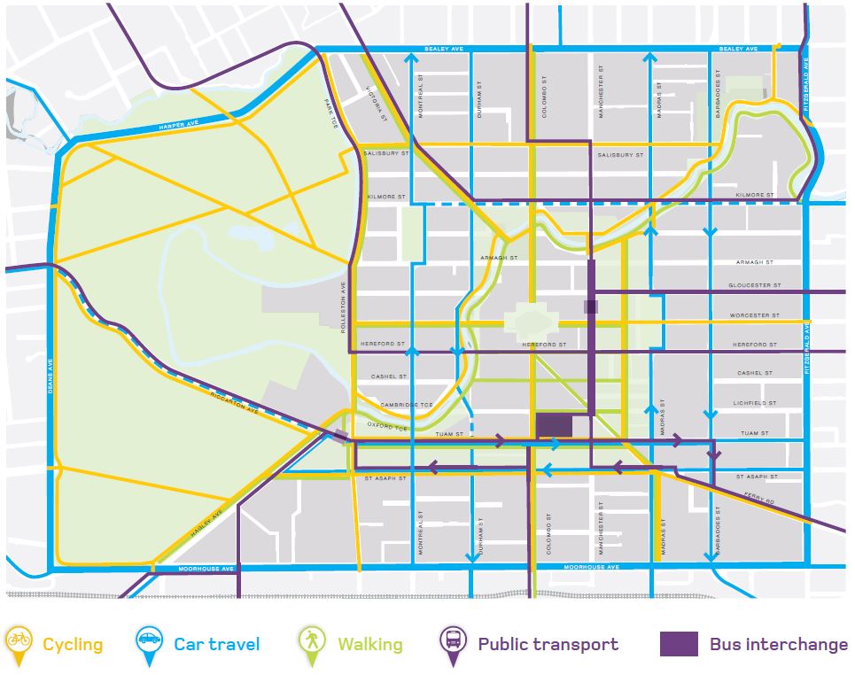
North of Moorhouse Avenue, Colombo Street has priorities for cycling, walking and public transport. There are three bus routes on that section (the Blue Line, and routes 28 and 45) and they travel in both directions. Between St Asaph Street and Tuam Street, buses travel in a northbound direction only; the southbound buses join Colombo Street via St Asaph Street. North of Tuam Street, there aren’t any bus routes (all the northbound buses turn into Tuam Street to go into the Bus Interchange) and the corridor has priorities for cycling and walking only.

On a weekday, there are 216 scheduled buses using Colombo Street between St Asaph and Tuam (142 come from Colombo Street south, and 74 turn on from St Asaph Street). And there are 401 buses on St Asaph Street east of Colombo Street (the 74 that turn right into Colombo, 45 turn left into Colombo, and 282 proceed straight ahead along St Asaph), so the AAC planning map not showing a public transport priority corridor for that section is an obvious mistake on the planning map. But back to Colombo Street; those 216 northbound buses are getting stuck in increasing traffic congestion.

As a transport geek, I’ve always been fascinated with Colombo Street for its unusual traffic characteristics. It’s the first street that I encountered during my professional life where traffic demand continually increases during the day; pre-earthquake traffic volumes peaked in the late evening. For my 2001 master’s thesis, I undertook microsimulation modelling of Colombo Street and the original Bus Exchange prior to its opening and successfully predicted its operational problems (as observed two months after opening) as well as its limited capacity (which, some years later, resulted in the on-street stops outside Ballantynes being significantly expanded). You will remember that back then, all north-south buses were on Colombo Street and travelled through the Square. This also preceded the hubs and spokes model that has been introduced in Christchurch since December 2012. Back then, there were significantly more buses on Colombo Street; close to 2000 per day.
Personally, I rarely use Colombo Street. Most often, it is when I return from mountain biking in the Port Hills on a Saturday. What I have observed is as follows:
- The intersection that causes congestion for northbound traffic is Colombo / Hereford; that was already the case in 2001 when I wrote my thesis.
- The difference between now and 2001 is, of course, that there used to be large numbers of buses using the Colombo / Hereford intersection and now there are no public buses travelling through the intersection in a north-south direction.
- After the CBD reopened post-earthquake, there was hardly any congestion on Colombo Street. Congestion has been building over time.
- At some point, northbound queues started to go beyond Cashel Street.
- Some time ago, I regularly saw the queues from Hereford Street extend past Tuam Street (which then impacts on public transport).
- Lately, the queues regularly go beyond St Asaph Street (see photo below; Sat, 24 Nov 2018 shortly before 1pm).

This is, of course, a reflection that activity returns to the CBD. Significant land uses that recently opened on Colombo Street include Hoyts and Tūranga (our cool new library). It’s also a reflection that Colombo Street quickly moves away from the priorities assigned to it in the AAC plan. It can’t provide priority to buses when they get stuck in general traffic.
It was, of course, known to planners that Colombo Street would naturally become clogged if nothing happened. It’s therefore proposed to restrict traffic through the Square; keep it open for access only but not to go through. If I remember rightly, this was first communicated to the public through the July 2017 consultation by Regenerate Christchurch on Cathedral Square. In June 2018 (one year later; a long time to think about consultation responses), Regenerate Christchurch stated that it is no longer proposed to close the Square for traffic.
I never for one minute believed that it would be straightforward to achieve the public transport priority for Colombo Street south of Tuam Street through closing the road through the Square. It is, however, necessary to do something. Here’s why:
- Buses on Colombo Street moving towards the Bus Interchange are getting stuck in traffic. This congestion won’t affect all 216 daily buses as it’s not happening all day long, but it will make bus travel increasingly unreliable.
- Congestion will continue to increase as the city centre isn’t nowhere near completed yet. The problem will only get worse over time.
- It’s not just the buses on Colombo Street that are affected but, now that congestion has reached St Asaph Street and further south, it also holds up buses travelling along St Asaph Street as drivers don’t have the courtesy of not driving into an intersection when the departure lane is blocked. And that affects many more (St Asaph Street) passengers than travel on Colombo Street.
How many people travel on Colombo Street by bus and in cars? It’s hard to know the exact numbers for several reasons:
- Council hasn’t undertaken an all-day traffic count on this part of Colombo Street since the earthquakes. There is a recent (May 2018) count at Cashel Street but it covers 5 hours only (and as I say above, as Colombo Street has a rather unusual daily profile extracting a daily total from 5 hours isn’t entirely straightforward).
- ECan does not know how many people are on their buses in any location as they only record boarding but not alighting. That’s why they want to introduce a “tag-on-tag-off” system as Wellington and Auckland have. And even then, on a per-route basis they guard their passenger numbers rather tightly as they are “commercially sensitive”.
Based on some assumptions how to extrapolate the count data, and bus loadings (which vary wildly by time of day and route), I estimate that Colombo Street carries, in a northbound direction between St Asaph Street and Tuam Street, around 5000 people in cars (drivers and their passengers) and about 3000 people on buses. That makes 8000 people (not counting people walking or cycling) of which some 37% are on public transport. In terms of vehicle numbers, my estimate is for 4400 cars per day and said 216 buses. Or in other words, 3.6% of the vehicles (i.e. the buses) carry 37% of the people that travel northbound in vehicles. I’d be happy to update these assumptions with count data from the city council and bus loadings by ECan (if somebody would like to supply me with the data).
What we need to grow is public transport use (if the reason for that statement isn’t obvious to you think climate change) and what makes public transport unattractive is when it’s slow and, even more so, unreliable. All would be fine if car volumes were restricted to a number that didn’t cause problems for the buses.
So, what do we do? I suggest we turn Colombo Street into a cul-de-sac just south of Hereford Street. There’s a busy driveway half-way between Cashel Street and Hereford Street that serves the underground car park of the ANZ Centre (or you might think of it as the Triangle Centre; the side note is that when I observed road user behaviour there the other week, I saw more people leaving that car park on bikes then in cars).

Between this driveway and Hereford Street, I suggest that Colombo Street should become a pedestrian mall. I’m not suggesting that we debate the finer design details for years to come and then try and find some budget, for it all to happen in 2032 or thereabouts. I’m suggesting that the city council consult the public on the cul-de-sac concept and then make the gutsy decision to close the road; this can be done with some landscaping containers lifted into place overnight. Target date for implementation: February 2019. March 2019 would also be acceptable.

Let’s put some teeth to the AAC plan and implement the road user hierarchy for Colombo Street south of Cathedral Square as it was intended. If we don’t, we’ll continue to see bus patronage decline – it’s been declining since 2014 despite what ECan would like you to believe (but that’s another topic for another day).
Postscript
Michael Hayward of The Press interviewed me within half of day of the above blog being published. His article was good and balanced, and created a healthy amount of discussion. The Press ran a poll as part of their online version and 59% of readers ultimately supported the proposal to close Colombo Street.


Good thoughts Axel. I’ve always been surprised that, even pre-quake, you could effectively drive from one end of Colombo St to the other (it might have technically had some bus-only through lanes either side of the Square but they were always ignored). And even now I am amazed at how many vehicles attempt to use Colombo St to get through town; despite the uncoordinated signals along the route – evidently these people haven’t heard of our one-way streets. It does seem that sometimes you have to actually physically break the link somewhere for people to get the hint…
LikeLike
Indeed. It’s firmly embedded as a north-south route in many drivers’ minds and that will not change unless you put a physical barrier up. Yes, the bus only lanes were totally ignored and that includes the Police; to my knowledge there was never any enforcement. Driving along Colombo is painful but evidently, driving along Manchester is even more painful. Just look how many people are choosing Manchester as their route!
LikeLike
Nice article Axel. Are there any plans for the square out? I was talking to someone a few months ago who seemed to think it was being closed to through traffic then, although I never saw any plans.
LikeLike
Thanks, Chris. https://www.regeneratechristchurch.nz/cathedral-square/ is where Regenerate Christchurch displays its plans for the Square. They call it a “long-term vision” which is bureaucrat’s speak for “it’s not budgeted for”. They are incredibly vague on any statement on transport but were quizzed by the media at the time they released their vision on it; my blog post reports on what their CEO told the media. QTP did some network modelling and in their report (which is online), they also comment on Regenerate Christchurch being a bit vague as to what they actually want to achieved from a transport perspective.
LikeLike
I wonder if the consultation should ask about preferences for how to block it: Stainless steel bollards, digging up the road for groves of trees and raingardens, planter boxes, furniture like bike stands and seats, recreation equipment like a skate bowl or a basketball court…
Just wondering if the hairy arm technique would be useful. 🙂
LikeLiked by 1 person
What’s the hairy arm technique?
LikeLike
Intentional distraction: https://www.lifehacker.com.au/2013/12/use-the-hairy-arm-technique-to-deal-with-overly-critical-bosses/
LikeLike
Yes. The other advantage of talking about the specifics of how to block the road mean people would start visualising it more. It would be particularly good if before and after photos of roads where through-traffic had been blocked were included in the consultation documents, and photos of each sort of device to close the street.
LikeLiked by 1 person
Jeff Tumlin from Oakland would suggest some ‘road works’ would be ‘necessary’ that would block the road for three weeks or so, and use the ‘opportunity’ to measure what the traffic effects are…
LikeLike
That’s an interesting approach that I’ve never thought about before. Thanks for bringing it up, Heidi.
LikeLike