
Update: Some errors in the map below were corrected 9/11/2018
I’ve previously posted articles on what areas of the city can get to the CBD in half an hour combined walking, waiting and bussing time. One assumption implicit in this was that people are happy walking for quite long distances in some cases.
In reality most people won’t walk that far to catch a bus. I live 1km (10 minute walk) from my nearest frequent bus stop and that can feel like a long way, especially if I’m only wanting to make a short trip.
Although the upper limit for how far people will walk to a bus stop changes for each individual, international best practice is to try to design for about 400m (~5 minute) walk for a typical bus service.
Below is a map showing which areas of Christchurch are within 400m of a bus-stop, categorised based on their level of service provision; frequent (core) service in blue, lower frequency (city connector and cross-town links) in green, and areas further than 400m from any bus service in red.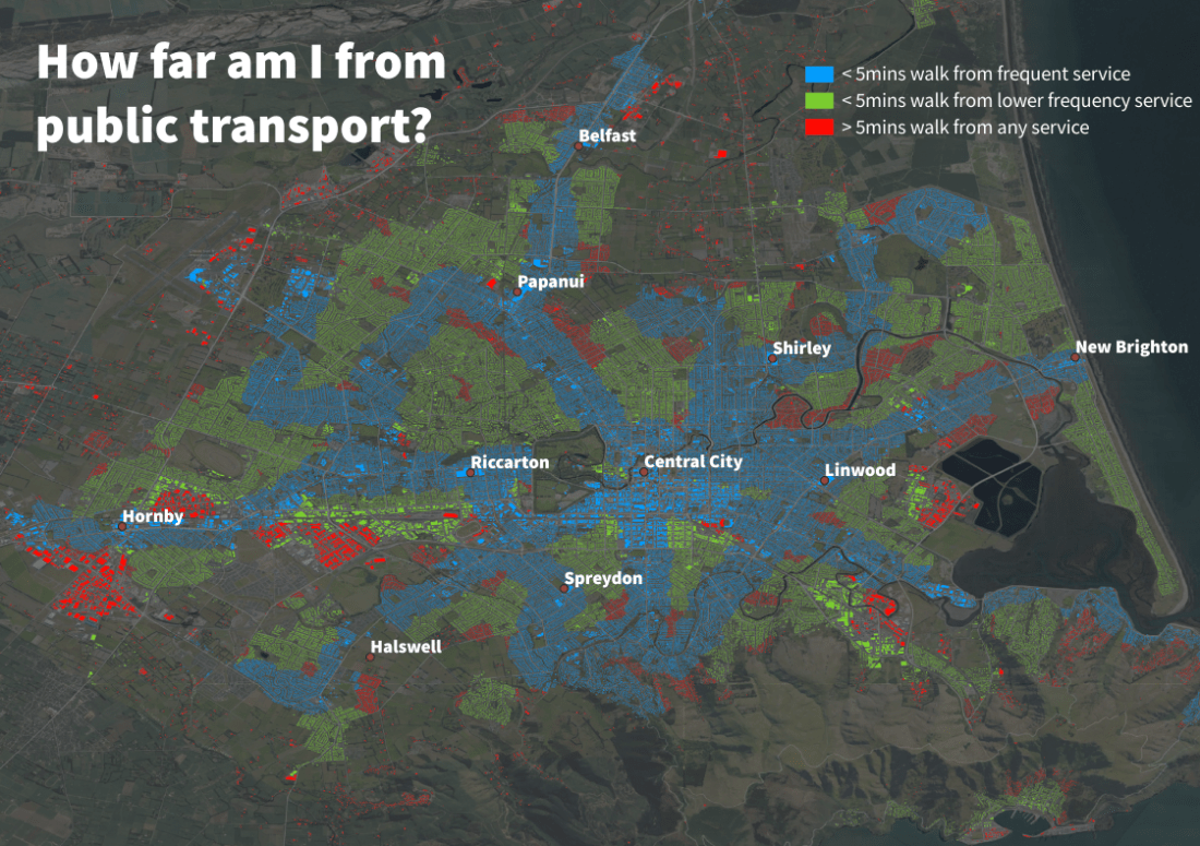
Distance from bus stops. Blue = 400m of a frequent route, green = 400m from lower frequency route, red = more than 400m from any route. (credit Greg Edwards)
A few things which stand out to me from this:
- A sizeable portion of the city is well served, being within 400m of a frequent service. I haven’t crunched the actual numbers but looks like maybe about a third of the city is covered in blue.
- The central city and inner suburbs are well served by frequent services. As you get further out the gaps between core routes get bigger.
- Even some of the inner suburbs have only lower frequency bus service e.g. Fendalton, Merrivale, St Albans, Addington and Spreydon.
- There is a notable lack of service in the north-east (Shirley, Burwood, Aranui). Is this to do with the Avon river, as a physical barrier, increasing the costs associated with providing a bus service?
- Large industrial areas around Wigram and Hornby are poorly served by public transport.
- Despite living reasonably close to the city centre (Hoon Hay) my house is in a red area. I knew this when I chose to shift here, but I definitely underestimated how annoying I would find this, and how much less I catch the bus as a result.
Going forward it would be interesting to do the same analysis with the proposed RPTP network and compare it to this – maybe a future blog article.
Another useful comparison is how this aligns with bus mode share recorded in the 2013 census – I’ve included a map below.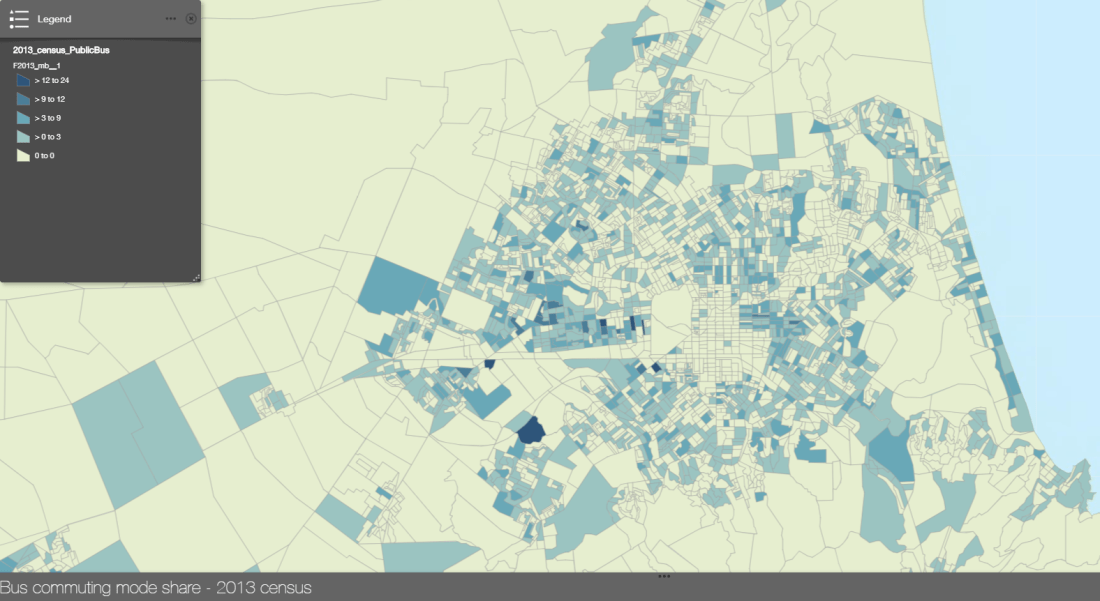
It’s not super easy to see correlations, but the Riccarton Road corridor stands out with higher bus rates than anywhere else in the city. I don’t know why one little zone in southwest Halswell has such high bus rates – maybe just a random spike caused by the relatively low numbers in each zone.
Where do you think we should be trying to improve coverage in Christchurch? One thing to keep in mind is that many of the areas that have poor coverage are like that for a reason – circuitous street layouts that don’t suit bus routes, low density housing, low density industrial areas etc.
Where is your house? Is its colour what you expected to see? Would you walk more than 400m to catch a bus?

Interested to see what changes with new routes http://www.metroinfo.co.nz/promotions/Pages/Bus-routes-changing-from-Monday-29-October.aspx
I expect my place will change from yellow to red with the deletion of the eastern end of route 145
LikeLike
That’s a shame. I guess it probably is one those pockets where public transport is difficult – not on a main route to anywhere else and low density of activity. Ecan talked in their 30 year plan about “demand-responsive” services for areas like this. There wasn’t much detail but I think it’s something like you order a minivan to come pick you up and drive you to the nearest high-frequency route.
LikeLike
Yes, its about time we started moving towards running PT systems like airline travel.
Its seems like a much more legible way to run PT as long as the on-demand transit is available and also meets the goals of providing:
a) a comprehensive coverage network
b) express travel between all hubs (which is far faster than fixed route all stops & would reduce the gap between car travel time & PT travel time)
c) potentially more efficient, (subject to modelling)
1) On demand transit from home to nearest primary or secondary transit hub (equivalent to getting a taxi from home to an airport)
2) Transit hub to transit hub direct express transit (equivalent to flying CHC to SYD)
3) On demand transit from transit hub to destination (equivalent to taxi from airport to hotel)
Where the demand between OD hubs is too low there may be some additional main hub stops. (equivalent to, say, home – CHC – SIN – LHR – MAN – local Manchester destination)
There might be some fixed routes in the network as well where there is a stretch of destinations – eg in CBD or along Riccarton Road.
Even the on-demand segments could have two service levels & prices – pick up from home or pick up form local catchment point (for those willing and able to walk)
LikeLike