This article first appeared on Brendon Harre’s blog and is republished with permission.
Christchurch has a well defined spatial problem but it lacks a well defined spatial solution.

The spatial problem is that 55% of future residential growth is planned to be outside the apple and inside the banana. This is a problem because this part of the ‘fat banana’ spatial plan only has motor vehicles as a transport option.
Christchurch has identified it needs to transport more people in fewer vehicles to avoid the city becoming chronically traffic congested. Unfortunately its current spatial settlement pattern does not support this desired transport mode shift. The city needs a better spatial plan.
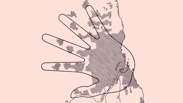
An example of a well defined spatial plan is Copenhagen’s Five-Finger Urban development plan, which dates back to 1947. Each finger has a commuter rail line supporting residential and commercial settlement. Between each finger is protected green space.
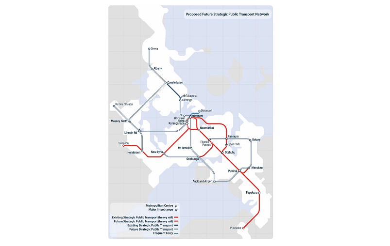
Auckland has developed a spatial plan in the form of a congestion free network of new rapid transit services that will cover every corner of its unique geography. Auckland has secured funding totalling $28bn to implement this spatial plan.

Wellington has a well defined V shaped linear corridor spatial plan that extends rapid transit services up the Hutt Valley in one corridor and up to Porirua and the Kapiti coast in another. Let’s Get Welly Moving has advocated for making this linear model more useful by providing a new rapid transit service -light rail or trackless trams -that extends the tip of the V down through the CBD and out to the airport.
The Transport Minister Phil Twyford recently announced a $6.4bn funding package, including $2.2bn NZTA indicative funding for rapid transit, for Wellington to implement this project over 20 years. There will be a 40/60% cost share between local and central government.
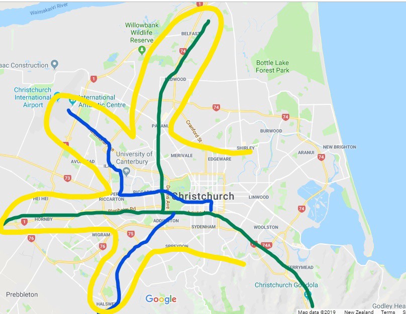
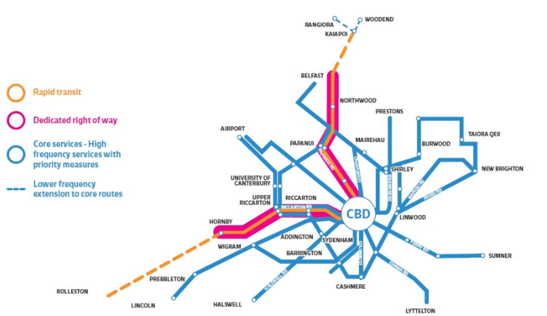
In Christchurch a voluntary organisation called the Canterbury Housing and Transport (CHAT) club has been investigating new housing and transport solutions for the city. It has conducted workshops looking at what should be the first step in creating a rapid transit network. My interpretation of those workshop results (above) is the collective wishes of attendees could be best provided by the tram-train Karlsruhe model, that over time creates a congestion free network that has similarities with the Copenhagen Hand spatial plan.
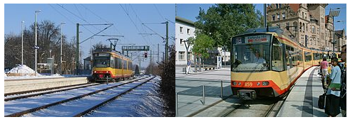
The Karlsruhe model commenced service in 1992, the service provides a connection between the regular railway network (picture on left) and the city’s local tram network (picture on right). The whole system is now called the Karlsruhe Stadtbahn. Passengers can travel from distant towns such as Baden-Baden directly into the city centre of Karlsruhe. The tram-trains bridge the inconvenient distance between the main station and the city centre. For most trips, the number of train transfers has been reduced significantly.
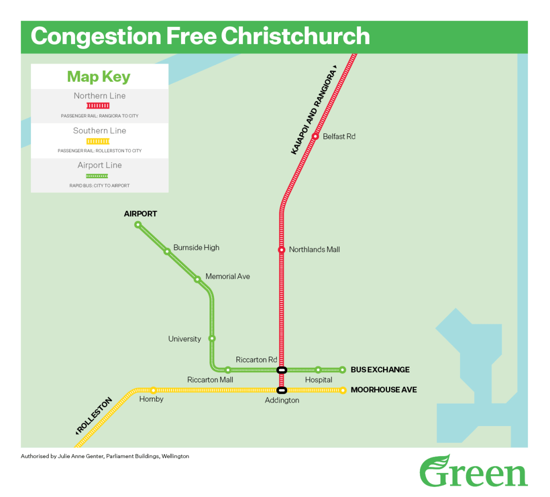
Christchurch’s Hand could be mapped as a cartoon three finger and thumb hand. In the future additional fingers could be added. Such as a southern 4th finger down to a housing/commercial regeneration of the Princess Margaret Hospital site.

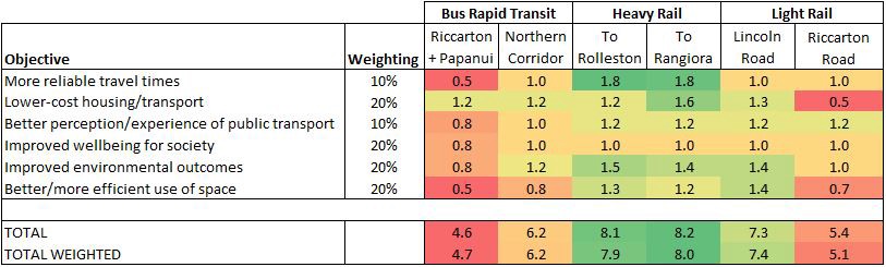
The thumb is the northern rail corridor. This would be the first corridor of the hand built to rapid transit status. In the workshops this corridor achieved the highest priority (weighted score 8.0).
The index finger starts as bus priority connecting the CBD to the University and Airport (bus priority on this route is currently being upgraded). The index finger using the Hand model would connect to the rail corridor at a new Riccarton station. This finger is later upgraded to light rail (weighted score of 5.4).
The big finger (2nd finger) is the southern rail corridor. It is also the first corridor to be upgraded to full rapid transit status (weighted score of 7.9)
The 3rd finger is light rail to Halswell which would come in stage two -as it has a weighted score of 7.4. It can be later extended towards Prebbleton or Lincoln.
The palm is the intensifying inner urban area of Christchurch. It requires a network of new cycle-lanes, reduced speed roads, micro-mobility infrastructure services, better car parking management and better bus priority roads. In the first instance bus priority would make a city-centre loop by connecting a new Riccarton and Moorhouse Ave train stations with the CBD. The ‘palm’ urban area is an area of high car parking demand and high traffic congestion that needs greater transport mode choice.
A tram-train loop was unfortunately not part of the workshop discussions so it doesn’t have a weighting. A tram-train loop could like bus-priority connect a new Riccarton station to the central bus exchange and to a new Moorhouse station. If the palm contains this rapid transit inner loop it would allow all the fingers direct access to the CBD. I would suggest the tram-train loop would be implemented in stage two of the ‘Hand’ model.
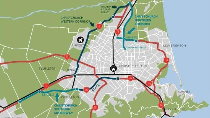
There is a Canterbury Regional Public Transport Plan being considered by the various local bodies of Greater Christchurch. This is a two corridor linear spatial plan for rapid transit. There is no fixed recommendation regarding rapid transit mode, leaving the option open for rail (given the route meaning light rail), bus rapid transit, or “trackless trams” (trackless trams are being hotly debated in Wellington currently). The CHAT club workshop gave the Belfast to CBD to Hornby route with bus rapid transit the lowest weighting score of 4.7.
Why did the CHAT club workshop not like the option of upgrading existing roads to rapid transit as depicted in the above image i.e upgrading the core bus service to a rapid transit corridor on Main North road, Papanui Road to the CBD and out to Riccarton Road, Main South road?
I can think of two maybe three reasons.
Grade separated transport infrastructure induces demand.
Grade separated transport infrastructure is not unique to rapid transit, motorways are also a grade separated transport infrastructure. It has two aspects;
- Protected corridors preventing traffic coming from the side -motorways have no side streets and no driveways.
- Grade separated intersections -think Christchurch new airport gateway bridge that goes over the end of Memorial Ave.
Grade separated infrastructure allows higher speeds -cars can safely travel on motorways at speeds of up to 100 km/hr in New Zealand.
In effect grade separated transport infrastructure reduces distance.
Christchurch has two grade separated infrastructures nearing completion -the northern and southern motorways.
The CHAT club workshops has aimed to create a rapid transit network with similar grade separated features to motorways, that can carry similar volumes of people, without the negative externalities of congestion and climate change CO2 pollution.
It seems that the outcome of these workshops is attendees did not believe that bus priority on existing road corridors that in the future is upgraded to some form of rapid transit will properly provide corridor and intersection grade separation. I think attendees collectively expressed a belief these corridors will lack reliable speed of travel needed to compete with the new motorways.
Motor vehicles taking the motorway from around Belfast or Hornby will get to the CBD much faster because the motorway routes are more direct and the speed of travel is much higher. 100km/hr versus the proposed rapid transit road corridors on local arterial roads which have speed restrictions of 50 or 60 km/hr.
I think some advocates for the proposed Belfast and Hornby to CBD rapid transit corridors believe it will achieve the same impressive increase in patronage results as Auckland’s northern busway. The North Shore busway services (NX1 and NX2) for example grew by a whopping 39.6% in the 12 months from March 2018. Unfortunately they are comparing apples with oranges. Auckland’s northern busway is faster than the neighbouring motorway because the motorway is congested and the buses have their own congestion free motorway lanes.
If rapid transit cannot induce demand for a transport mode shift then the entire business case for its provision is flawed. Cars will remain the overwhelming dominant transport mode (85%) for Christchurch. Increased motor vehicle numbers will discourage an inner-city urban ecosystem that provides transport choice -micro-mobility, walking and cycling etc -because of safety concerns. In others words Christchurch will not achieve transformative urbanisation change like Auckland and Wellington are experiencing.
Christchurch’s rail corridor is better grade separated. Obviously there are no side streets or driveways on this corridor and there are many overbridges already in existence. Rapid transit using the existing rail corridor could travel safely and reliably travel at higher speeds, therefore it is more likely to induce demand. Using the existing rail corridor as an underlying transport skeleton for Greater Christchurch seems to intuitively make sense to Cantabrians.
Integrating transport with housing
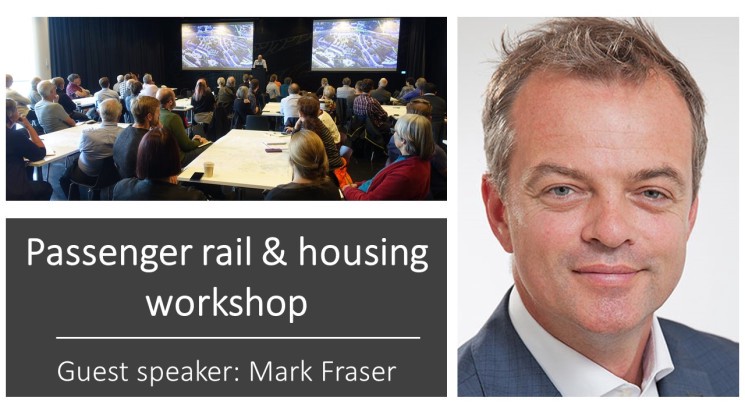
CHAT club attendees have had discussions about density done well. Density in the order of 100 dwellings per hectare not 20 to 30 that is the most Christchurch is currently achieving. In particular, there was a fantastic talk by Mark Fraser about the successful commercial experimentation with density being achieved at Hobsonville in Auckland, which was master planned by HLC a commercial of subsidiary of HNZ.
There have been discussions about how density done well is hugely beneficial to public transport because it increases patronage and takes advantage of public transports economies of scale, making services much more commercially viable.
These sort of urban development projects require large greenfield or brownfield sites, so that an equivalent to HLC, which in Christchurch is likely to be the Ministry of Housing and Urban Development -Urban Development Authority can master plan the entire site.
These Urban Development Authority housing projects adjacent to rapid transit could easily build ten to twenty thousand houses over a period of one to two decades in Christchurch. A targeted rate on the development areas could fund the local government 40% rapid transit contribution.
On the heavy rail corridor there would be greenfield opportunities to the north around Belfast. Potentially there could be good brownfield opportunities too as much of Christchurch’s older industrial areas are located by the railway. There is a gradual relocation of these older industrial areas out west to the Hornby to Rolleston industrial areas. This opens up the possibility of regeneration projects. The Tannery is a private sector example of this.
The Lincoln Road light rail line I suspect scored so highly because it opens up huge greenfield sites near the centre of Christchurch that can integrate housing with rapid transport.

Cost or bang for the buck
The workshops were not designed to consider cost but I think in the evaluations many people did.

Light rail on existing corridors cost about $60 to $100m per kilometer. Trackless trams an untried technology claims to be cheaper but that is using already built high quality boulevard roads that can sacrifice a dedicated lane for the trackless trams. This condition is not met in Christchurch. A dedicated grade separated corridor will need to be constructed regardless of whether the corridor surface is tarmac or rails. In places along the proposed corridor this will require road widening thus necessitating the purchase of private property. To keep the rapid transit corridor operational as much as possible the road will need to be strengthened and underground services will need to be moved. All this costs money.
The on the road distance from Belfast to Hornby via the CBD is about 20km so to upgrade this route to rapid transit will likely cost $1.2 to $2bn. This is not an impossibly large figure -Auckland and Wellington are getting bigger rapid transport packages -but is it the best bang for the buck?
The Green Party at the 2017 election claimed re-establishing commuter rail in Christchurch and creating a high frequency airport bus rapid transit line would cost $400m. There are various transport reports that double tracking, putting in passing loops etc needed for a every 15 min rail service would be around this sort of price. Building this would create half of the ‘Hand’ and would leave a significant sum of money if there was $2bn rapid transit ‘pot’ to complete stage two of the ‘Hand’ -a tram-train CBD loop and the Lincoln road light rail line to Halswell.
If Christchurch can form a consensus supporting a well defined spatial plan then it will be in a strong position, like Auckland and Wellington has done, to advocate for funding to implement the plan. I would argue the Christchurch Hand is the best spatial plan for the city.

I note Copenhagen also has had a long term policy of removing CBD car parking spaces which supports their PT approach.
LikeLike