I was recently emailed by someone who is currently living overseas but returning to Christchurch. She asked where is the best place in the city to live?
I’m sure a few readers have some passionate views on this. But I’ll run through my views first.
These things in particular are important to her:
- Good access to public transport is critical.
- Somewhere it’s safe for her kids to bike around is critical.
- A view over the sea would be nice, although not critical.
First let’s look at good public transport access. Here’s a map of the high-frequency bus routes:
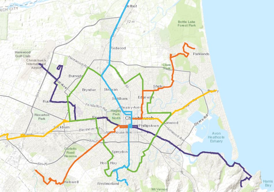
Riccarton and Central City are by far the best as they have multiple high-frequency routes coming together. But beyond that, this map doesn’t narrow it down too much – about half the city is within walking distance of one of these routes. In my experience the micro-location is more important – catching the bus from a house 100m walk from a bus stop that has a safe crossing point can be a world apart from catching the bus from a house 800m away without a safe crossing.
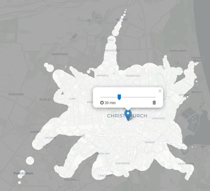
The mapnificent website is a great way to visualise how good public transport accessibility is for different part of the city. Drag the drop-pin around to see how much of the city you can access in 30 minutes.
If you want to catch the bus regularly you may want to be on one of the routes where buses are reliable and fast. Here’s a map showing which of these have bus lanes to help with this (just noticed there are a couple of sections missing off the map, but still gives you the idea).
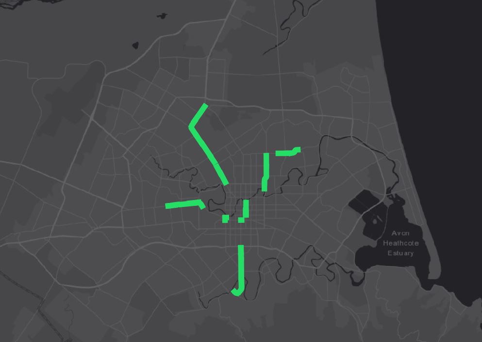
This does narrow it down quite a lot. A proviso is that there are various plans in the works to extend these over the next few years – e.g. Lincoln Road will be getting some soon, but hopefully quite a few other places will as well.
Here’s a map showing major cycleways (not all of these are built yet, it doesn’t include the really good cycleways that follow the new motorways, and some of the routes have changed slightly since this map was produced).
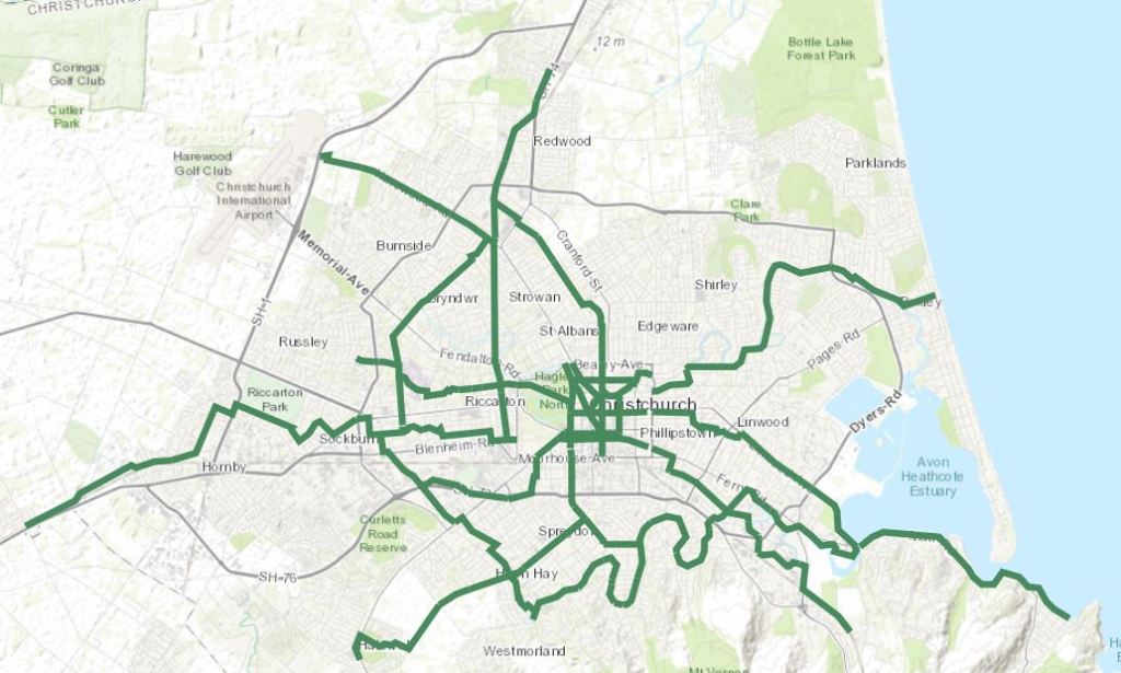
This also doesn’t narrow it down too much as most of the city is covered, especially when you add in the motorway cycleways to the north and southwest. But again the micro-location is important, you want to be able to get to one without crossing any major roads. And the location at the other end is important – ideally your kids’ school would be right on one of these (the routes were chosen to try and service as many schools as possible so hopefully that’s not too difficult).
One thing that can make a big difference in a neighbourhood being safe to raise kids is lower speed limits. These are the areas I’m aware of that have blanket 30km/h or 40km/h limits, rather than the default 50km/h.
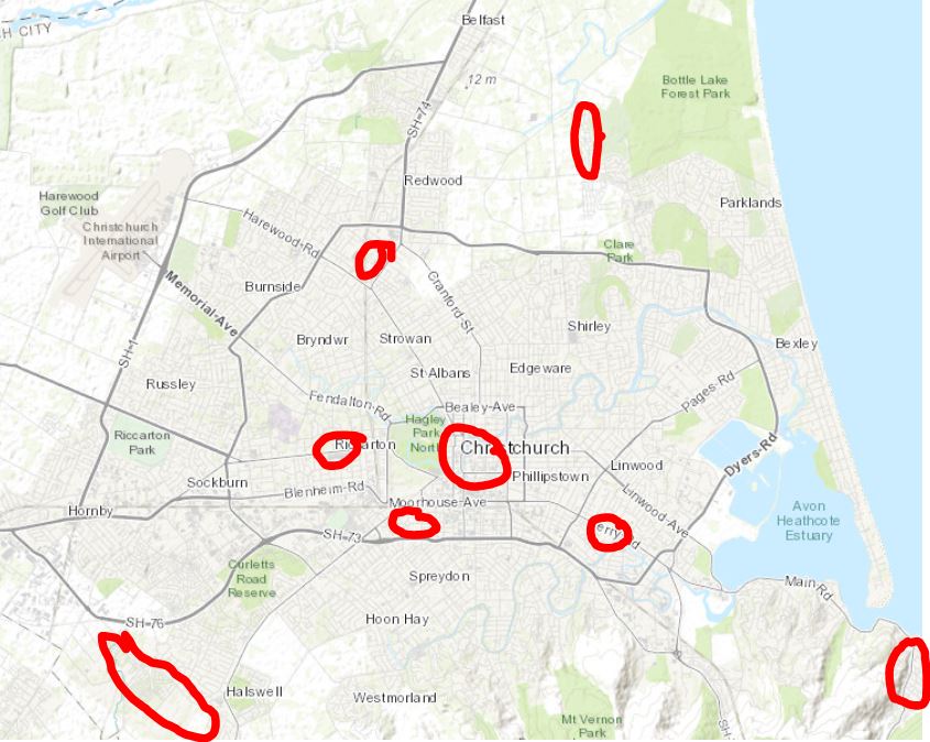
Again CCC are doing quite a good job of rolling out more of these across the city, so this map might look a lot more comprehensive in a few years.
Here is a map of e-scooter activity in the city.
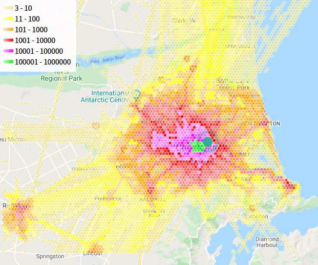
It shows that, if you find using e-scooters handy, locating more centrally will be best, or on a few key spines: towards Sumner, Halswell, and Airport.
Wanting a view over the sea does narrow down the options a lot. I’d say the only areas of the city that have really good sea views are these one:
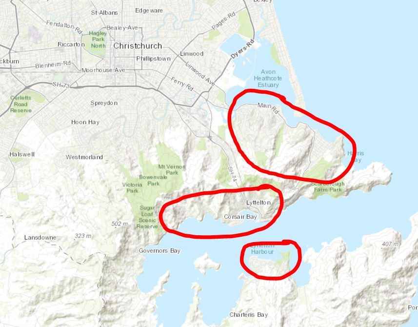
The two lower ones have pretty poor public transport. Some people do live in Diamond Harbour and catch a ferry/bus combination into the city. But generally public transport is limited out here.
Mt Pleasant and Redcliffs do have the purple bus line at the bottom of the hill, but the walk to a lot of houses is much longer and steeper than it looks on the map. Micro-location would be important. And a lot of these hills suburbs are pretty unsafe for kids to bike around (I know Mt Pleasant has some steep, windy roads that people drive down very fast). Sumner would be better from a bus and bike perspective, but is flat so mostly doesn’t have the elevated views. New Brighton is similar – very close to the sea, but flat so you don’t get the same elevated views.
The hills around Cashmere might be a good compromise – you get some great views across the city (although not really of the sea), but it is also quite easy and safe to bus and bike around. But you do pay a premium for that.
Another compromise might be, rather than a sea view, try get somewhere fronting a big river reserve or wetlands (of which Christchurch has plenty). You do need to be careful with liquefaction risk with that.
There are a few of these types of areas within walk of high-frequency bus routes and cycleways. (this one is the Heathcote River through Aidanfield).
The homes.co.nz website is really good to quickly get an idea of what you’ll pay for different areas.
It’s refreshing to see someone thinking about transport when picking where they will live. People do this in other cities but in Christchurch I reckon quite a lot of people don’t include this in their thinking nearly as much as they should.

When we moved back from the UK I got a map from the AA and drew circles around the schools, and lines along the cycle ways. We ended up in bryndwr on westholme st, close to Waimairi and Heaton schools and walk to northlands or quickly cycle off roads into the city. Around St Martins was the other option that would have ticked those boxes.
Living by the sea or on the hill would have been good, but would have locked in car dependency.
Schools and jobs are superimportant for where you might end up
LikeLike
Being currently in the process of selling and buying houses again, this is certainly relevant! I’ve always aimed for a place handy to a bus route although, as you say, relatively little is too far away from one. My personal preference is also for proximity to the hills and river for nice places to walk/bike (BTW, you can get some pretty decent views of the sea from Hillsborough and Huntsbury hills).
I’ve always wondered why many of the planned cycleway maps have this bizarre diagonal route going through the northwestern part of the central city – there is no corridor here! Also, you missed the grand-daddy of low speed neighbourhoods in Christchurch – Charleston, off Ferry Rd, which has been 40km/h since the early 2000s (part of it is now 30km/h along the neighbourhood greenway route). And now much of St Albans/Edgeware is being moved to 30-40k zones as part of the Northern Arterial Downstream Effects work.
LikeLike
We are in the process of moving down to Christchurch and deciding on which area to move to looking at good schools and proximity to town and ease of cycle and transport links.
LikeLike
Where are you looking Dawn? It’s my comment above – we went for Westholme St in Strowan and very happy with it. There’s a bus at the end of the road, cycleway on the other side of waimairi school, and high schools/intermediates are also handy
LikeLike
Late to the party here! I encourage you to do an update to all the above every few years as it’s such a great article.
I grew up in Heathcote Valley but moved to Melbourne in 2017.
My partner and I bought our first house on Tilford street in Woolston in 2014 and everyone we knew looked down on that location but I feel like it’s an amazing nexus of all the best Chch has to offer.
After several years of living happily car-free in Melbourne, one worries how easy that will be once we return.
LikeLike
Thanks! It hadn’t occurred to me to do an update but I’ll think about that now. A fair bit has changed in the last few years. Watch this space!
LikeLike