
With all the talk about light rail in Auckland there’s been a bit of tea-break talk down here about how it might work in Christchurch. Down here, light rail to the airport would also mean light rail to the university, teacher’s college, the city’s largest shopping mall, several large schools, Hagley Park, Cricket Oval and Central Hospital, and would replace the city’s busiest bus corridor (Riccarton Road), so is one of the more obvious route candidates.
In my previous 2 posts I showed maps demonstrating that about a third of Christchurch’s population can get to the CBD in half an hour or less by public transport. I then showed how this would increase by roughly 50% if we just put in more bus lanes/priority and increased frequencies. Next I showed how introducing heavy rail would increase this by a further 10%.
In this post I look at how the introduction of light rail would affect this.
I used the same methodology, and added in not only the CBD to airport light rail route, but two others as well, mainly just out of curiosity:
- CBD to the Port Hills along Colombo Street
- CBD to New Brighton
There was some talk a while back around using the red zone to provide a light rail corridor out to New Brighton. My route just uses the existing bus route rather than the red-zone, but the idea is similar.
All three routes follow existing high-frequency bus routes so, in terms of my modelling, the only effect is that they’ll move people a bit quicker than buses. I assumed an average speed of 30km/h, in line with what Auckland’s light rail is expected to run at (compared to 20km/h for buses in bus-lanes).
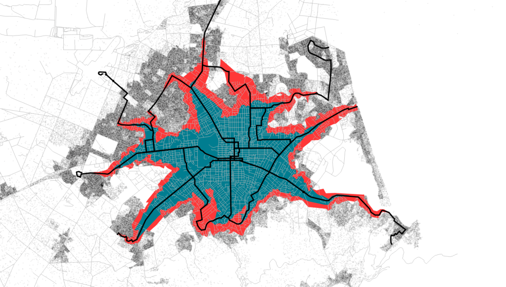
First up is a recap map from my first post, showing the 106,000 residents currently living within a 30 minute public transport commute of the CBD (blue), along with the 163,000 residents that would be living within a half hour commute of the CBD if we increased frequencies and speeds of buses (red).
Next is a map showing how much more could be brought within a 30 minute commute by introducing these three light rail routes (green).
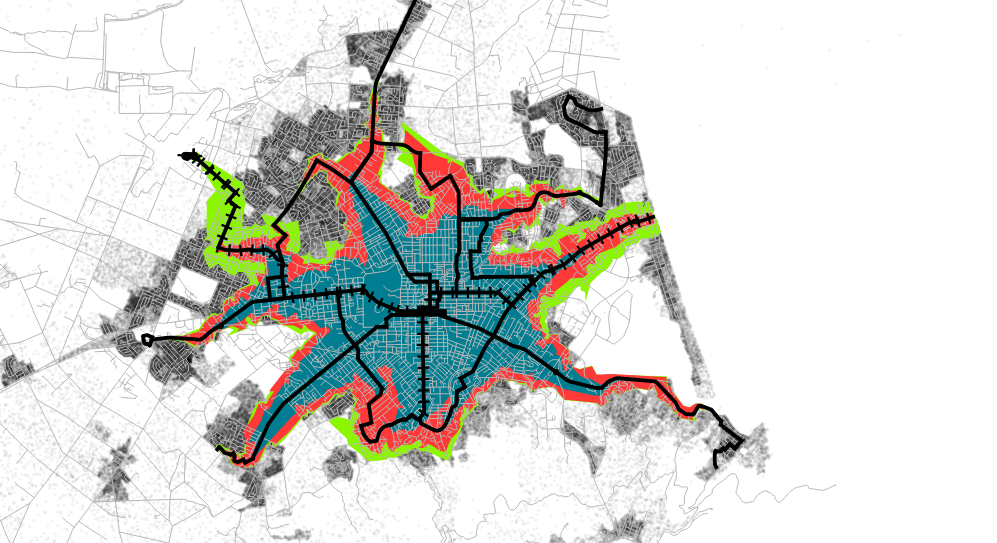
It shows some significant increases along the three routes, bringing another 23,000 people within a 30 minute commute of the CBD to a total of 186,000 (54%).
The most significant difference is on the airport route, where it would bring the airport and surrounding areas within half an hour of the CBD. It would also make it quicker coming in from the east and south, extending the walking catchments surrounding the routes.
Although I’ve use the term light-rail throughout this article, this analysis would apply equally to bus rapid transit, provided it was done properly so that it does actually achieve the faster 30km/h average speed.
I think this shows that light rail is worthy of further investigation. It brings several new areas of the city into a 30 minute commute of the CBD. In reality, and like heavy rail, light rail would also bring a whole raft of other benefits not related to travel time that I haven’t covered here.
Do you think light rail is a good idea for Christchurch?

I’m glad you mentioned bus rapid transit at the end, because I was beginning to wonder how an in-street light rail system was necessarily any faster than a good bus system on the same corridor. The only two options at your disposal for speeding things up are (1) coordinated with priority at intersections and other constriction points, and (2) fewer stops along the way (all this assumes dedicated corridors, and the same boarding time delays and travel speeds along the corridors, for either bus or LR). I guess the point is that I don’t really care which mode gets used, so long as we provide key basics like true corridor priority.
LikeLike
Interesting link Glen, i hadn’t read that before. My understanding is that in theory BRT can be as fast as LRT, but it usually isn’t in practise because it’s much easier for the design to be watered down to appease opponents (like all Christchurch’s bus lanes to date have been). LRT does have higher capacity so the max future demand needs to be carefully looked at when deciding which is the better option.
LikeLike
This might be of interest to some readers: http://www.stuff.co.nz/the-press/opinion/perspective/4292604/Light-rail-only-part-of-the-solution
LikeLike
As Lincoln takes off as a major international ag science hub it might be worth considering light rail further south (Ecan’s already proposing a 15min frequent service to Lincoln by 2020)…
LikeLike
Another advantage BRT would have over light rail is at the ends of the faster BRT corridor, buses could cheaply split off into multiple directions, to serve multiple suburbs using the slower general purpose traffic roads.
For instance if Buchan St was connected to Manchester St via a bridge or tunnel at Moorhouse Ave. Then there could be a BRT corridor from Brougham St to Edgeware Rd (with a one block diversion to the central bus exchange).
This would allow north/south buses to speedily traverse the most congested central parts of the city at an average speed of 30kmhr. Christchurch would get its own congestion free rapid transit system!
At the Edgeware Rd and Brougham St ends the buses could split to multiple destinations in the north and south of the city.
If we built a train station at Moorhouse Ave at the same place as where the BRT route crosses. We would create Christchurch’s first rapid transit connecting service i.e the start of congestion free network!
The BRT service would connect the Moorhouse Ave exchange station, let’s call it MX for short, with the central bus exchange, which could be called BX.
This solves the problem of the suburban train system not being able to service the centre of Christchurch.
LikeLike
Chris would you be able to model my Brougham to Edgeware Road BRT route?Where Buchan and Manchester roads are connected by a bridge or a tunnel.
LikeLike
Yea I’m keen to. I’m just trying to model the ecan draft 30 year plan first, then I’ll see if i can model your BRT.
LikeLiked by 1 person
How much does the map expand if suburban bus- and train-catchers use electric scooters to get to their stop? Double the walk speed or so?
LikeLike
Each spike would expand wider, potentially by a significant amount. People can already get to buses quicker using bikes, skateboards etc, but it seems like doing this has never become that widespread. It will be interesting to see if e-scooters do.
LikeLike
The best approach is to be mode neutral and work with the rapid transit corridors that Ecan and the Joint Public Transport Committee have proposed in their new RPTP.
That corridor can start off as a busway like the Northern Busway in Auckland that is capable of being converted to LR if the traffic density really takes off over a timeframe.
It looks like one of the RT corridors goes north which will be a red flag to people campaigning for heavy rail passenger services going north. In fact any of the corridors that run parallel to a rail corridor at any point will be attacked no matter how it is set out. The Public Transport Users Association has been rabidly attacking the light rail development in Auckland because they want heavy rail to be prioritised, even though there is already a lot of HR development and the LR corridors are a long way away from the HR lines and open up new areas.
LikeLike