
As I wrote about last week, Ecan have released their draft Regional Transport Plan for consultation. Their proposal included, among other things, almost doubling the number of high-frequency routes from 5 to 9, and creating 2 rapid transit corridors; one to the north via Papanui and Main North Roads, and one to the west via Riccarton and Main South Roads.
I thought I’d put this plan into my GIS model I’ve written about previously to see how much of the city would be able to access the city centre in half an hour, including wait time. I assumed average speeds of 30km/h for rapid transit (similar to what Auckland’s light rail is expected to operate at), and 25km/h speed for new core bus routes (roughly the average speed of existing buses). I left frequencies at 15 minutes, even though there was a suggestion some routes may go to 10 minutes.
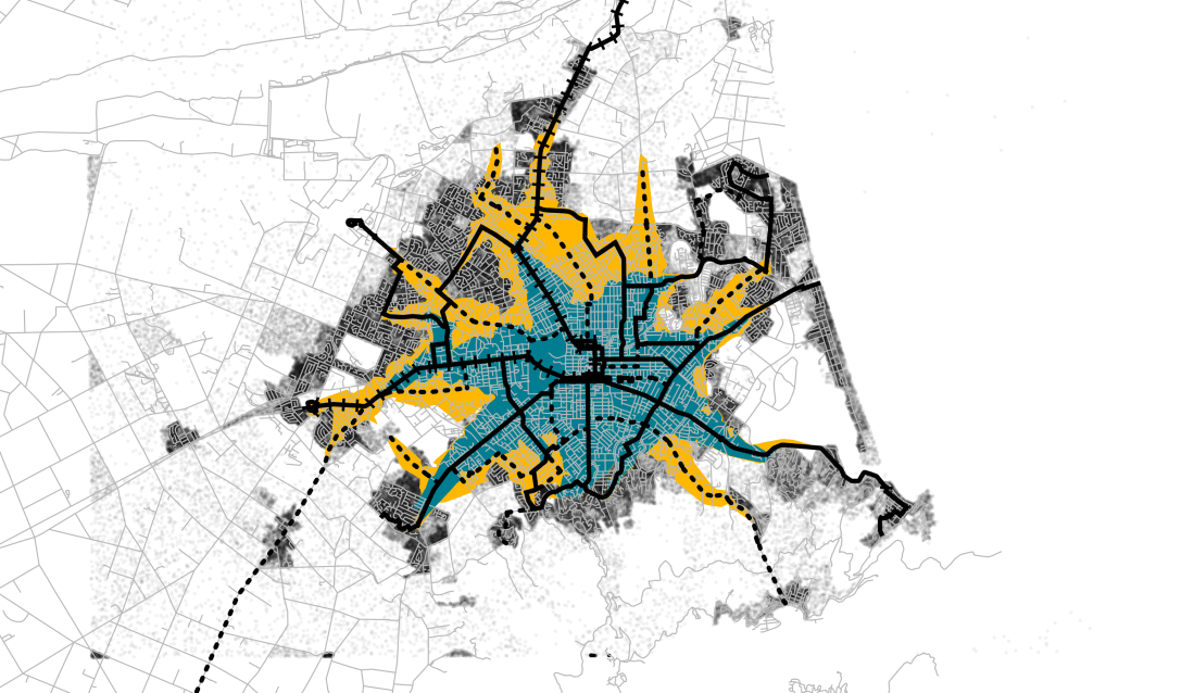
The map below shows the current half hour catchment in blue, together with the catchment under the proposed plan in yellow. The solid black lines are the existing core bus routes, the dotted lines are the new core bus routes, and the rail lines are where rapid transit is proposed (although it may not necessarily be rail).
Currently 106,000 residents (31% of the population) can get to the centre in half an hour. As a reminder, my previous posts showed this could be improved by:
- Adding bus priority – 119,000 (34%)
- Doubling frequencies – 147,000 (43%)
- Adding bus priority and doubling frequencies – 163,000 (47%)
- Adding heavy rail to west, north and southeast – 170,000 (49%)
- Adding light rail to northwest, south and east – 186,000 (54%)
This draft proposal would increase the number of people able to get to the CBD in half an hour to 183,000 (53%).
I think this is pretty good, especially for a plan that says it’s trying not to prioritise coverage too highly. The 4 new core routes do a pretty good job of plugging the gaps in coverage, although there are still a couple of gaps (e.g. Bryndwyr, Bromley).
The plan also caters to expected growth (and growth that’s happened since 2013). Some of the new core routes will service areas that have been recently developed so aren’t included in my model (Wigram, Prestons). And the two rapid transit routes allow expansion towards the rapidly growing Rolleston and the south, and Rangiora and the north. A part of me thinks the Riccarton Road rapid transit would be better heading north up to the airport via the university.
Do you think the proposed 30 year plan looks about right?

2 thoughts on “How Far in Half an Hour – Draft 30-year Plan”