
This first appeared on Brendon Harre’s blog and is published with permission.
On Tuesday the 26th of February I explained my Fat Banana analysis and its implications to the committee for the Greater Christchurch Partnership. They are considering the wider city’s settlement pattern and spatial plan. I believe I received a good hearing. Committee members took notes and asked constructive questions.
The following pictures is my slide presentation. Under each picture is my speaking notes for that slide. Material in brackets and the addit at the end I did not present (they are my hindsight thoughts!).
I would like to talk about integrating housing with rapid transit.
I think it is important to understand the scale of Greater Christchurch’s housing and transport issues so that we do not gift the next generation harms -like chronic traffic congestion or a housing crisis.
To avoid these harms we need to understand some facts about our city.
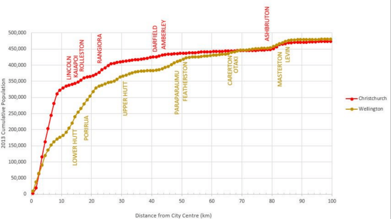
Christchurch is bigger than Wellington.
We are New Zealand’s second biggest city.
There are many more people living within 10 kilometers of the centre of Christchurch -over 300,000 versus less than 200,000 for Wellington.
Even if the respective cities are extended out to include Rangiora or Upper Hutt -Greater Christchurch is larger.
The above graph is based on the 2013 census –since then Greater Christchurch has grown by 2.1% and the Wellington region by half that –so the gap between Christchurch and Wellington is widening.
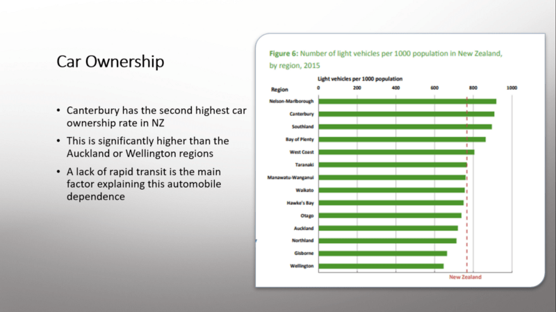
Yet Canterbury has 909 cars per 1000 people.
While the Wellington region has 647.
This is despite Greater Christchurch being much more compact compared to Wellington.
Christchurch’s lack of rapid transit is the main factor explaining this automobile dependence.
The Wellington region has developed around two integrated rail corridors –up the Kapiti Coast and the Hutt Valley.
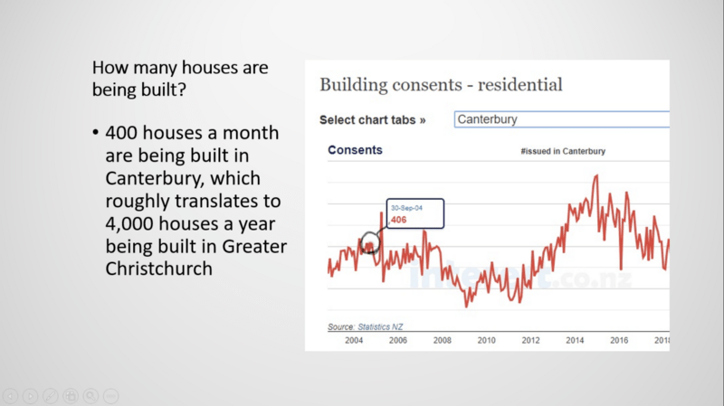
Canterbury compared to other regions has built the second highest number of houses in recent decades.
Greater Christchurch is building about 4000 houses a year.
Canterbury’s building consent graph shows the effects of the global financial crisis and the post earthquakes rebuild.
The build rate was particularly high from 2014 through to 2016.
4000 houses a year appears to be the long term trend for the wider city.
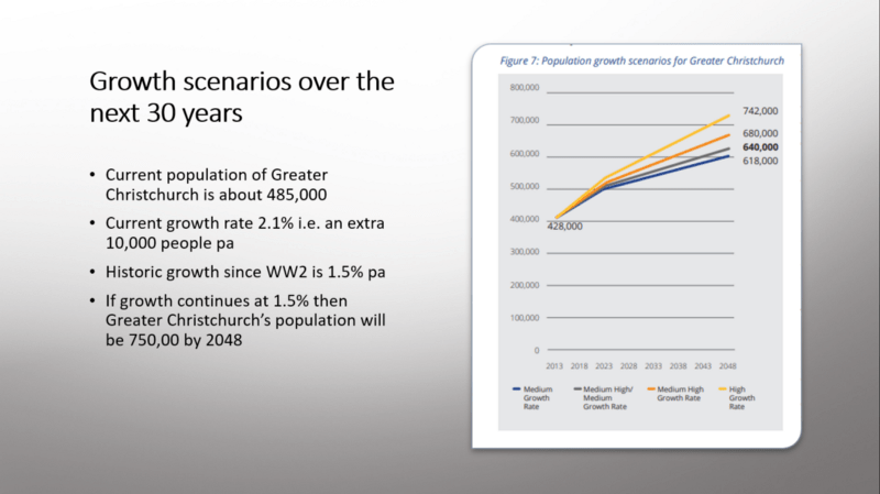
Greater Christchurch’s current population of 485,000 is very similar to Auckland’s population after World War Two.
As Christchurch transforms into a international city of about ¾ million in the coming decades, we should learn from Auckland’s growth experience, to avoid the problems they have experienced with chronic traffic congestion and a housing crisis.
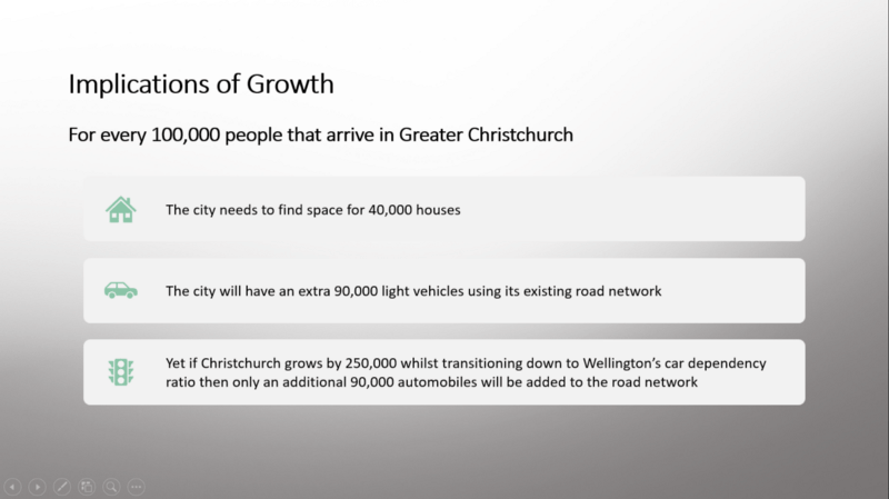
Christchurch is though heading towards significant traffic congestion problems.
In the coming decades hundreds of thousands of extra cars will be using the existing road network, which is largely fixed in size.
More cars using a fixed amount of space can have only one result –increased traffic congestion.
If Greater Christchurch can reduce its car ownership rate down to Wellington’s level then this problem is much reduced.
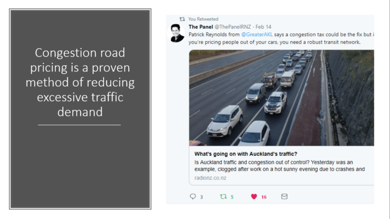
Congestion road pricing would be a way to manage chronic traffic congestion.
Pricing a scarce resource –in this case road space –is a common method of resource allocation.
The Tax Working Group for instance advocated for this.
I would encourage the committee to think about road pricing.
But in order to implement road pricing fairly, alternative transport modes like a robust rapid transit network are needed.
To integrate rapid transit with housing we need to understand the scale, pace and density required.
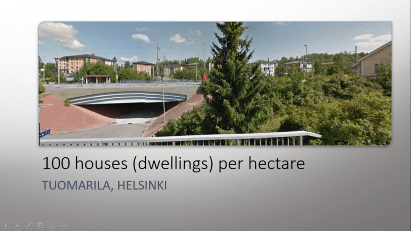
Depicted is a view of Tuomarila train station –23km and 25 minutes from Helsinki’s central train station.
I had a very similar view from my apartment from 2005 to 2012.
During that time all the apartments in this view were built i.e. when I first moved to Tuomarila this was a view of green fields and forest.
Would Cantabrians consider this sprawl and therefore not supported it? Can the equivalent be built in Greater Christchurch is a key question for the region?
Porirua in the Wellington region is a similar 20km or so distance from Wellington. There is a plan to revitalise Porirua by building thousands of state and Kiwibuild housing at higher densities in cooperation with central government.
(Add: If Helsinki and Wellington are ok with building transit oriented developments 20+km from their city centres why should Christchurch have a problem building at less than that -mostly between 10 to 20 km from its centre?)

The green dots is Tuomarila train station.
The red dot is my old apartment.
Within the blue lines is most of the housing close to Tuomarila train station built between 2005 and 2012.
This totaled about 1000 houses at a density of about 100 houses per hectare.
During this time the number of passengers waiting at Tuomarila station increased from about twenty every 15 minutes to fifty.
It is this sort of ridership numbers, based on favourable land-use patterns that guarantees the long term success of rapid transit.
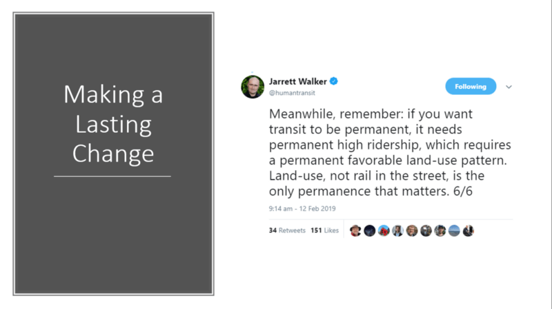
Jarrett Walker is a transit theorist and international public transport consultant.
The lesson for Greater Christchurch I take from Jarrett Walker’s advice is if a good proportion of the 30 -40,000 houses the city will build in the coming decade was built close to rapid transit then the economics of ridership numbers etc would ensure the rapid transits long term success.
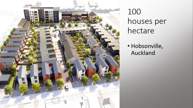
New Zealand does have an example of building at the pace, scale and density required.
HLC a subsidiary of HNZ master planned Hobsonville, which it then tended out blocks for development.
One such block is depicted here –it is Ngai Tahu Property’s Kerepeti development, which is coming onto the market now.
It has 100 houses per hectare.
HLC has encouraged developers to experiment with density in a way that is appealing to the New Zealand market.
Hobsonville’s experiments with higher density housing have been commercially successful.
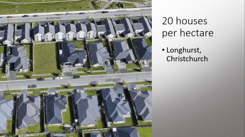
Christchurch though is only building at about 20 houses per hectare.
If rapid transit tried to service this sort of urban environment it would only have 20% of the patronage of Tuomarila’s train station.
Low passenger numbers would make it difficult to provide high frequency services at reasonable fare costs.
Christchurch’s existing suburbs despite some infilling are relatively low density of 20 to 30 houses per hectare.
For rapid transit to be a success in Greater Christchurch some anchor higher density walkable communities built around rapid transit stops will be needed.
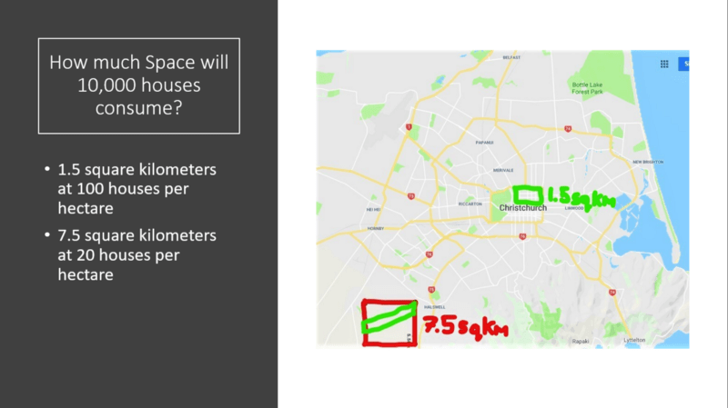
Remember Greater Christchurch is building 4000 houses a year –that is 40,000 houses in a decade!
As I will describe the spatial plan is for over half this housing to be built in greenfield areas.
10,000 houses is also the number of Kiwibuilds the city should be expecting –although there seems to be no plan –or at least no public plan –for where these houses should be built.
10,000 houses consumes 1.5 square kilometers of land at 100 houses per hectare once public spaces like streets and parks are accounted for and 7.5 square kilometers at 20 houses per hectare.
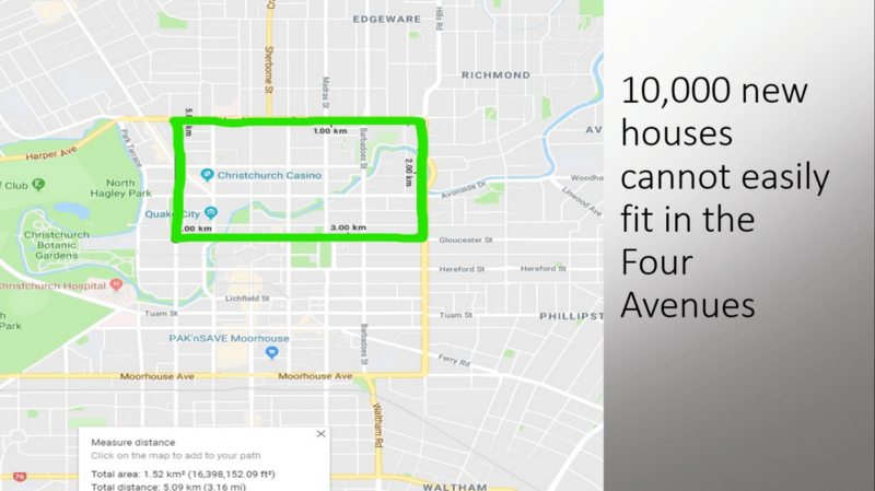
10,000 houses at 100 houses per hectare would consume 40% of the private land within the Four Avenues.
Some housing will go into the centre of Christchurch.
But not all the housing growth can be accommodated in the central city.
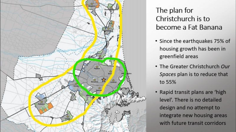
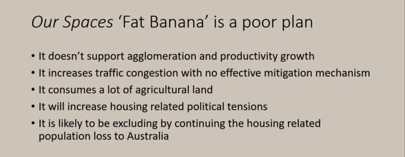
Greater Christchurch has an urban development spatial plan called Our Space 2018 -2048.
55% of housing growth will be in greenfield areas –in the areas marked on the map in green or orange (blue is future industrial).
Greenfield housing is mostly located outside the apple and inside the banana.
People –even some local government politicians and officials have argued they do not want Christchurch becoming a fat banana.
My day job is working as a registered nurse in Hillmorton Psychiatric Hospital.
I am used to working with people who have delusional beliefs -I assist to orient them to reality, so they do not harm themselves or others.
Denying the fat banana is happening is a delusional belief –it is a failure to see the new suburbs being built on the outskirts of Christchurch and around the city’s six main satellite towns.
Denying the fat banana is happening means sensible coping strategies cannot be implemented.
This could have harmful consequences.
Probably not to the Councillor or official who will be comfortably housed with a short commute to work –but to the next generation struggling to cope with unaffordable housing and terrible traffic congestion.
(Read slide)
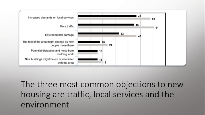
The three main political objections to new housing are the effects on traffic, local services and the environment.
The first economic effect is that more people in a city increases productivity and incomes.
Commonly a countries largest city has the highest income, the second largest the second highest income and so on.
For instance Lyon is France’s 2nd largest city and has the 2nd highest income.
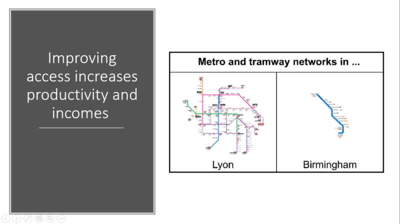
The exceptions are cities with poor accessibility, such as Birmingham.
Especially accessibility at peak times when productivity effects such as agglomeration are at their highest.
Birmingham has a 33% productivity gap due to the city effectively being half its actual size at peak travel times.
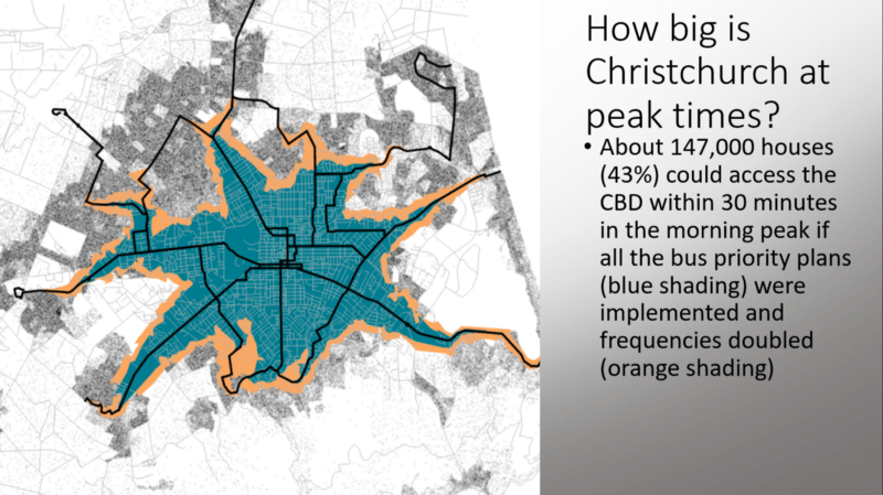
If Greater Christchurch only relies on bus priority plans then the majority of housing growth will not be serviced by public transport in a timely manner.
Residents in new housing areas will therefore be reliant on private motor vehicles travelling on increasingly congested roads.
This will affect productivity and incomes in the future.
The second main economic effect is high housing costs exacerbates inequality and is a barrier of entry into productive labour markets.
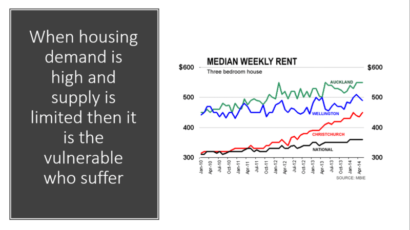
Christchurch should understand the effects of supply and demand for housing because we have experienced the extremes of the housing market.
This chart shows Christchurch’s median rents increased $130 from $320 per week to $450, a 41% increase in three and half years from October 2010 to April 2014.
On an annual basis this took $6,500 out of rental households budgets.
Renters couldn’t protect themselves from this unwanted event –there is no disaster rental insurance –all they could do is take the financial ‘bash’ or leave the city.
Fortunately house building ramped up between 2014 and 2016 as I showed earlier and this supply effect stabilised house and rent prices.
But 75% of this housing supply was in greenfields in low density automobile centric sprawl.
As a short term emergency response this is understandable –as a long term strategy less so.
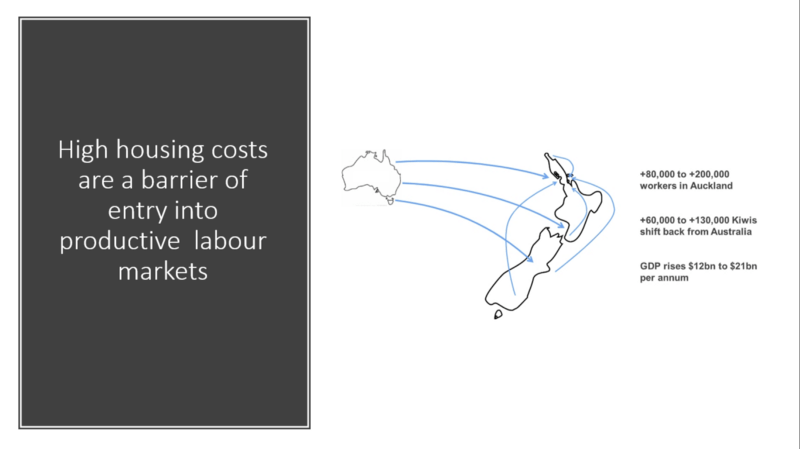
Economist Peter Nunns has modelling which shows 50 to 100% of the migration to Australia in the last generation is due to house building restrictions and a consequent lack of abundant affordable housing.
The Our Spaces spatial plan for Greater Christchurch is a trap.
It will have negative consequences as measured against the main housing supply related political and economic effects.
The banana will fight the apple for who incurs the economic gains and losses but the reality is all of Greater Christchurch loses.
It forces Christchurch into a devil’s choice.
Chronic traffic congestion or highly restrictive planning rules for house building.
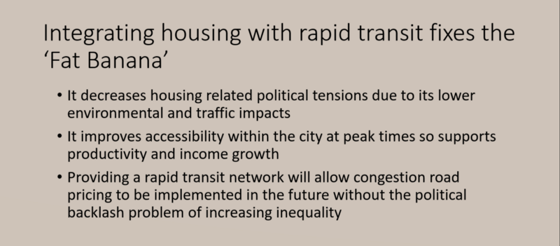
Building a comprehensive integrated housing and rapid transit network for all of Greater Christchurch is the route out of this trap.
(Read each point)
(Read each point)
(I have some ideas on how to assist New Zealand cities to build upwards from low density suburbs once rapid transit is provided. Please refer to my paper titled Can Great Design Help Solve the Housing Crisis?-A Master Planned Block Proposal)
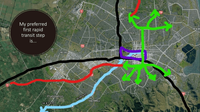
There are many potential first steps towards building a rapid transit network.
Use the existing tracks for commuter rail (in black), build a bus rapid transit spine connecting to the motorway network (green and red), build a tram/train inner city loop (purple), build light rail out to Prebbleton, plus many more…
Rapid transit has the potential to deliver corridors that can transport as many people as a four-lane motorway but without the traffic congestion dis-amenity consequences that motorways cause to inner city areas.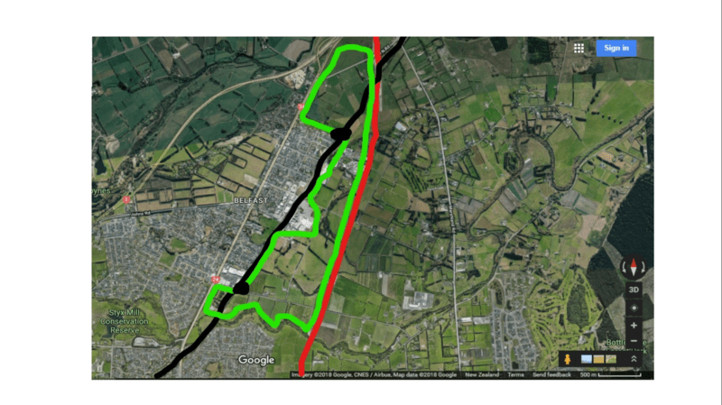
My preference from an integrated housing and rapid transit perspective is to utilise the existing rail corridor.
For example build housing at a density of 100 houses per hectare around two train stations in Belfast.
There would be similar opportunities west of Kaiapoi and east of Rangiora which I detailed in my written submission.
Bus priority lanes through Riccarton would connect train commuters with the CBD and Canterbury University plus the airport –over time this and other bus priority routes could be upgraded to light rail as passenger numbers grow.
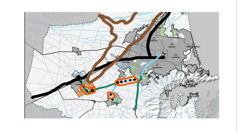 To the southwest of Christchurch, which is our fastest growth corridor, light rail is required because the airport noise zone (marked in brown) limits the building possibilities along the existing railway line.
Initially I would advocate building light rail to South Prebbleton.
In the future connections to Lincoln and Rolleston can be built.
Light rail would also provide another commuter rail connection to the CBD at Addington train station.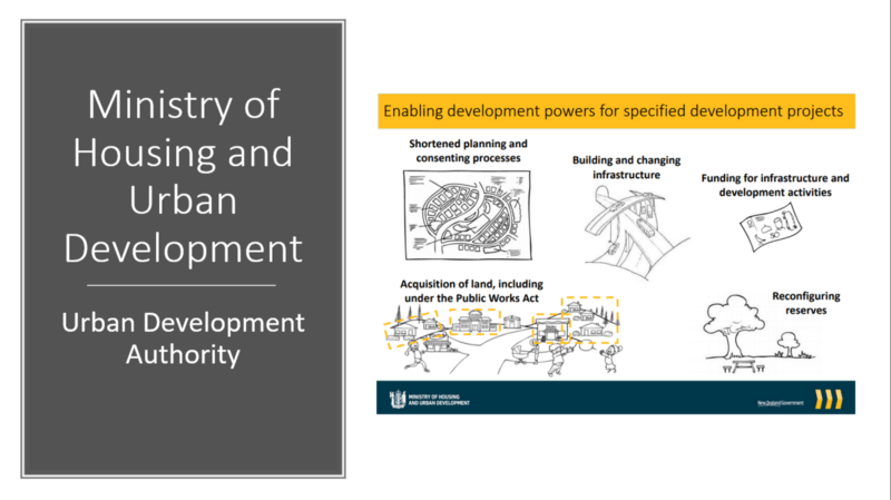
Christchurch’s local authorities would need to cooperate with the Ministry of Housing and Urban Development.
The Ministry has an Urban Development Authority that is gaining enabling powers to coordinate all the necessary government departments required to make an integrated rapid transit and housing project a success.
The Urban Development Authority has a goal of reducing the developmental time for specific projects from concept to construction from in excess of 5 years to less than a year.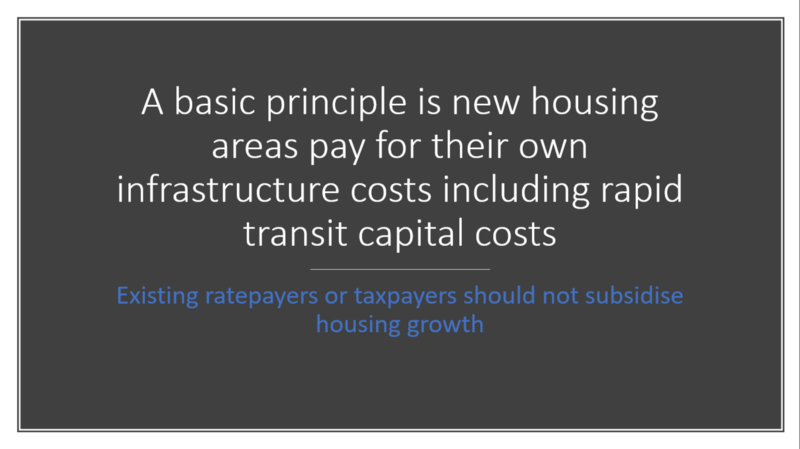
It is relatively easy once an Urban Development Authority has acquired a large green or brown field site to ‘capture’ the uplift value of the infrastructure provided to pay for the infrastructure costs.
For instance every property title created could either have an up front charge of say $50,000 to pay for the capital costs of rapid transit or the charge could be spread over time in the form of a targeted rate.
The targeted rate if it was paying a long term debt at say 4% would have an annual payment of $2000.
$50,000 times 20,000 houses which is the approximate number of planned greenfield houses over the next decade would generate $1 billion.
It would be possible in Greater Christchurch over the next decade for the Urban Development Authority to master plan ten walkable communities for 20,000 households around ten rapid transit stations.
For new households this upfront charge or targeted rate is not overly burdensome –especially if the houses was otherwise affordable and close to congestion free transport choices. Like Hobsonville the housing would need to be commercially attractive to buyers.
It is more problematic imposing a targeted rate on existing housing areas to pay for a new rapid transit services as residents would find a $2000 increase in their rates bill difficult to swallow.
Many residents would argue they do not need the rapid transit service so they shouldn’t have to pay for it.
Also because Christchurch’s existing suburbs are relatively low density -20 to 30 houses per hectare –there would be fewer houses within walking distance of any proposed rapid transit scheme.
(For these reasons, rapid transit schemes that do not have a large green or brown field component would not generate much revenue from targeted rates.
If Christchurch chose to build a rapid transit network for existing suburbs only, this would mean forgoing the possibility of generating something like $1 billion of funding from an effective rapid transit targeted rate scheme.)
Additional notes not presented
A good reference for this proposal is pages 181 to 186 in book Economics, Real Estate and the Supply of Land by Alan W. Evans. This section is about public land banking as a means of increasing housing supply whilst limiting sprawl. Also in this section is a description of the difference between negative planning where the government sector limits itself to placing restrictions on land use (New Zealand’s RMA is a negative planning tool) and positive planning where governmental entities play an active part in building the urban environment. This is a important conceptual difference to understand.
With regard to governmental entities being an active participant in the property market, there are some issues to be cautious about. The State acting as a land banker can result in over pricing of land, like the deliberate purchase and restriction of land supply in the centre of Christchurch to maintain high land values by the previous government after the earthquakes. Compulsory acquisition is also a blunt tool, that could be easily misused, especially for land that is returning to private ownership.
My preference would be to use a transparent voluntary land assembly approach and rarely use compulsory acquisition, especially not for land that will be sold back into private ownership.
An example of a voluntary approach is the Urban Development Authority (UDA) could use land readjustment which is a proven success overseas.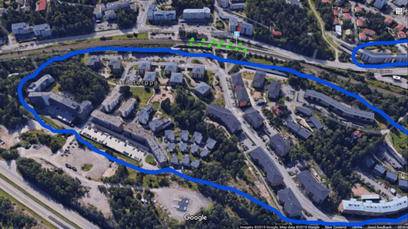
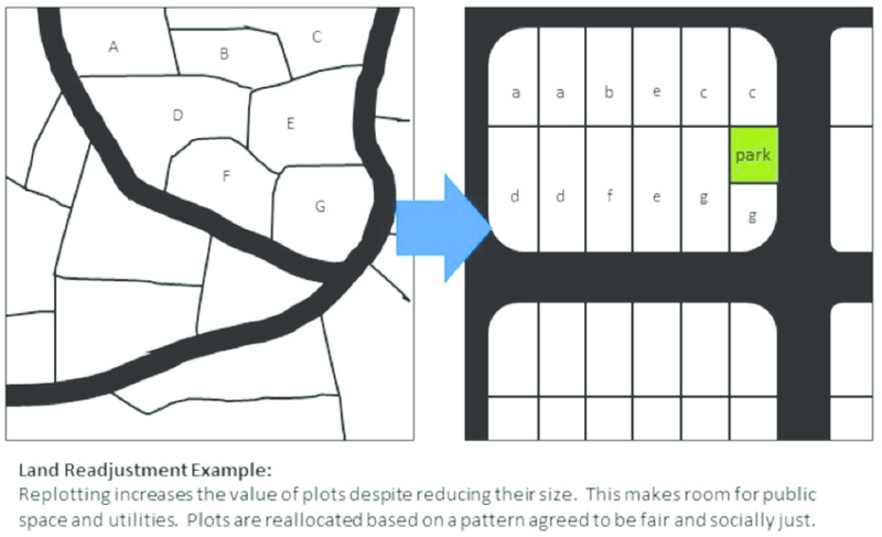
For land readjustment a UDA is the organising agent whereby landowners exchange larger rural zoned blocks of land for more valuable yet smaller blocks of land. It is more valuable because through a public process it is given residential zoning, it is fully serviced with streets, water mains, sewers, stormwater management systems, local parks and other amenities, it is within walkable distance of rapid transit and the land has been subdivided into multiple property titles.
I would still advocate for using targeted rates to pay for the capital costs of the infrastructure. The freed up land from land readjustment would go towards lowering the cost of public spaces -streets, parks, schools etc and for social and affordable housing i.e. state and kiwibuild housing. The transit provider could also get an allocation of lower cost land to build residential and commercial spaces. These rentals could help pay the ongoing operating costs of rapid transit.
This system would have significant environmental and social benefits whilst also aligning the different land owning groups interests in ensuring the commercial success of the walkable communities.
