A few months ago Wellington Regional Council commissioned economics consultancy Sense Partners to produce a study which I found really interesting. The methodology is complicated but the conclusion is simple.
Firstly they mapped how much rates each household pays, for different areas in Wellington.
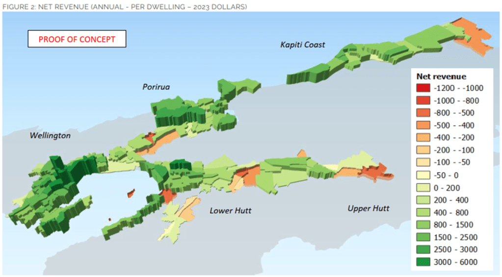
Like most of New Zealand, rates in Wellington are charged in proportion to property value (land + improvements). People who own higher value land, such as that closer in, pay higher rates, and people who own lower value land, such as that further out, pay lower rates.
They then looked at the costs to Council to service each area, again mapping them by cost per household. First up is local road costs. This is the amount that council has spent on each road, and also the amount spent on public transport. It excludes State Highway costs. The costs of non-arterial roads are apportioned to the area in which they are located, but the costs of arterial roads are apportioned to the homes of the motorists who drive along them, using census commuting data.
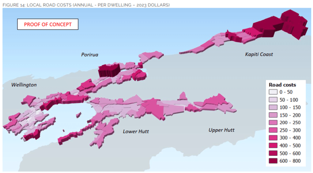
You can see that households that are located further out cost the most to service with roads and public transport, whilst households located centrally cost the least.
And finally they calculated and mapped the costs to service each household with three waters (water supply, waste water, and storm water).
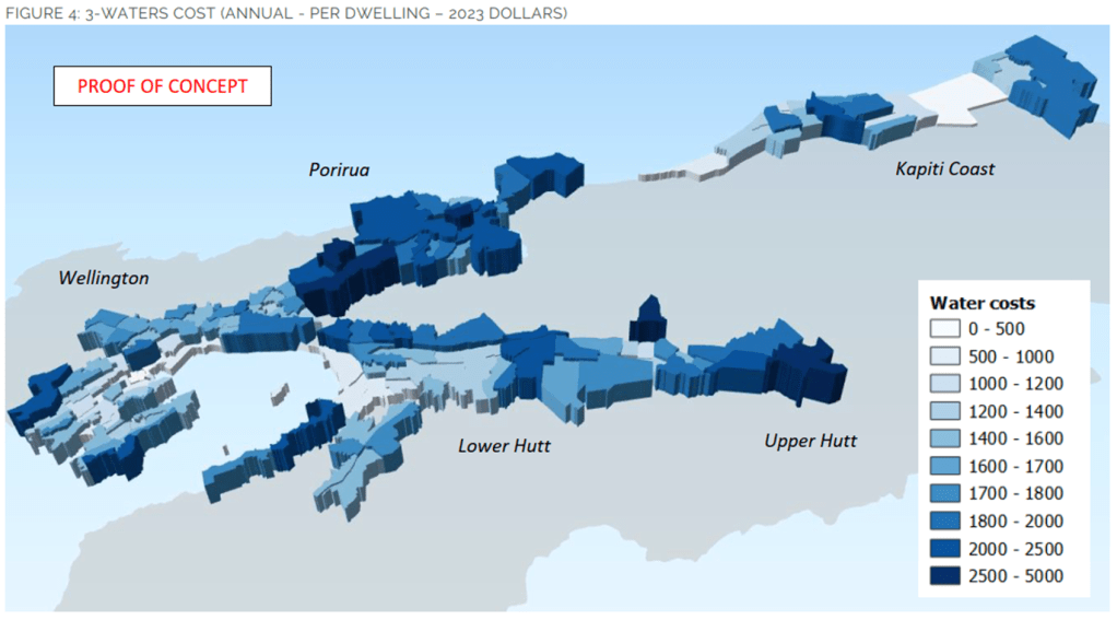
Again, the general trend is that lower density areas further out cost more to service each house; high density areas closer in cost less to service each house.
They also display this data on the graph below, which shows each suburb’s cost per dwelling on the vertical axis, versus its density on the horizontal axis. There is a very strong inverse correlation.
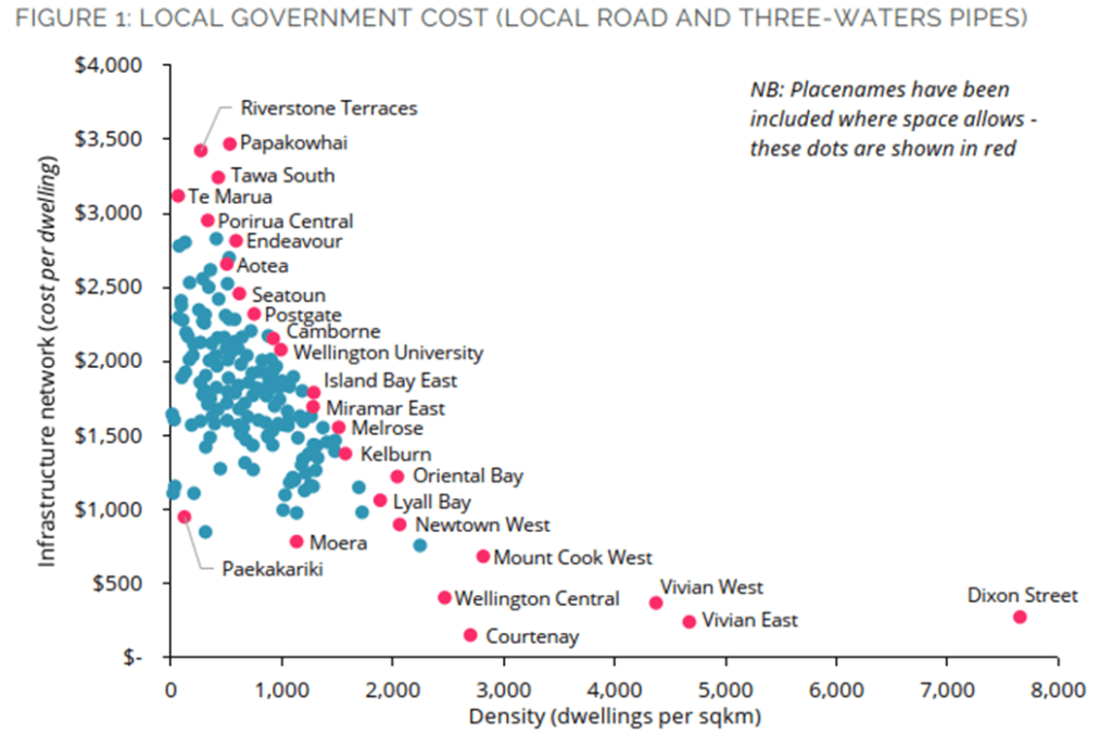
Hopefully this is intuitive. City planners have known for ages that sprawl imposes huge infrastructure costs onto councils that intensification of inner areas does not. But I really like the way they’ve mapped it out and made it very simple and obvious.
The study begs the question: wouldn’t it make more sense to charge higher rates for people who live further out and lower rates for people who live closer in?
The main reason councils like charging rates in proportion with property value is equity. It means that rich people pay more and poor people pay less, which is generally what you want.
However, if you come at it from a user-pays perspective, then it is a terrible idea and incentivises perverse behaviour like more sprawl and higher costs to councils. This is discussed in the report:
The overall conclusion is simple.

This exercise hasn’t been completed for Christchurch but I can’t imagine it would look any different – city centre residents are almost certainly subsidising the suburbanites and lifestylers in Waimakariri and Selwyn.
With the big Plan Change 14 on the verge of becoming operative, I think we’ve largely solved the “enabling density” part of the equation. The remaining question is whether it’s time for a conversation on our rating structures. As long as our rating structures make suburban sprawl artifically cheap, and conversely make intensification artifically expensive, then trying to get a better urban form is going to be like trying to push water uphill.
So personally I think that yes, it probably is time.

Very interesting. How do we get this information out to the general public?
LikeLike
Came across this after watching a Strong Towns video where Urban 3 did this for many cities including Auckland. How do we get the public and our councillors to understand this?
LikeLike