This post first appeared at TraNZport blog and is republished with permission.
There was good news recently, in Christchurch, when the Christchurch City Council unanimously agreed to reconsider how it manages the downstream effects of the soon to open northern motorway extension [Ed – Radio NZ article here]. In short, it recognises that the impact of more than 40,000 vehicles being funnelled into inner-suburban streets is not something that is desirable, and creates a lot more problems than benefits. It recognises that more needs to be done to discourage people from using there cars, that public transport alternatives are not up to scratch.
The question that needs to be asked is, how did this situation occur?
A little history…
Back in the mid-1960s the Christchurch Master Transportation Plan was produced which provided for a network of new and improved road links across the city. This included an improved arterial road network, which is where the one-way system and the quasi-motorway Brougham St come from, a network of cross-city expressways, largely built during the 1980s and 1990s as two lane roads like QEII Drive, and a not insignificant north-south motorway spine.
Over time, the motorway aspects of the plan were shaved back. Initially consisting of a northern motorway cutting through St Albans and the Central City, meeting a southern motorway in Waltham, with a short east-west motorway through Hagley Park and across the northern Central City (the much derided “Fendalton-Avonside Motorway”), the later aspect was cut, and the central section through the Central City was removed. Then, later still, the northern and southern motorways were cut back to terminate at Cranford Street and the west end of Brougham Street respectively. So, in essence, the current Christchurch Motorways built as part of the previous governments Roads of National Significance programme, were to complete this motorway plan from the 1960s. However, as you can probably guess, this is a fundamentally flawed plan.
The problem…
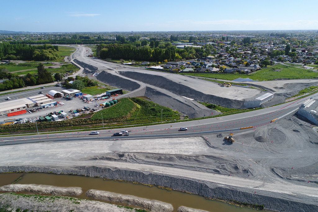
Ignore the (many) usual reasons for why investing in roads-only approaches is flawed, and consider that this plan is finishing a network that is no longer fit for purpose. For a start, the northern motorway will terminate into Cranford Street, depositing tens of thousands of vehicles per day onto a Christchurch City Council controlled road. The Council were expected to deal with the downstream effects of this, which effectively meant acquiescing to the governments roads-only approach to transport policy. To boot, there was no money for public transport to mitigate the effects of the motorway extension, no congestion management, and HOV lanes have had to be battled for, with only small wins so far.
The government effectively built State Highway One into inner-suburban Christchurch despite the fact that State Highway One had long ago moved to the west. So it begs the question of why this link was built as it was. A motorway without a proper role, dumping thousands of vehicles daily onto suburban streets, without he city left to pick up the tab and deal with the effects. How this decision came to pass is beyond me, it’s simply appalling.

This is possibly the worst road funding decision I have ever heard of in New Zealand, because it’s based on completing a plan that is woefully out of date. It actually makes things worse than they were, by shifting the problem to an area that is even less equipped to deal with it, as well as doubling-down on an unsustainable approach for linking Waimakariri and Christchurch. Although I wouldn’t have been in favour of it, given the previous government’s penchant for roads, I’m actually surprised they didn’t throw in cash to widen Cranford Street while they were at it. This would have locked in auto-dependence, and simply shifted problems again, but at least you could say that they were applying some sort of consistent logic, even if it was flawed.
Solution?
The Downstream Effects Management Plan (DEMP) attempted to effectively deal with the extra traffic, however it did this by making the journey as nice and lovely as possible for cars rather than taking into account the impact these vehicles would have on the community, both at a micro and macro level. Thankfully, this was plan was canned by the Council a few days ago, and I have to say that the speeches given by a number of councillors were incredibly encouraging. Reducing car dependence by providing mitigation through improved public transport and encouraging higher occupancy of vehicles (i.e. car pooling) is certainly something that should be a priority, yet the initial approach didn’t seem to do enough.
So what should happen? This is potentially a turning point for Christchurch, and you would hope the city pivots from here and begins to look at its transport provisioning with a more open eye. To get people to use public transport some big changes are necessary, beyond anything the city has considered before.
Ultimately, any investment in public transport will need to be good enough to attract people if serious mode shift is desired. The first, and most obvious, action that could be done is improving bus services. That’s no easy feat as buses will be stuck in the same traffic as cars, but introducing HOV lanes on the motorway, and bus lanes on Cranford Street, would be a good start. Improved park and ride facilities would also be desirable, and I see that a park and ride facility at QEII Drive interchange is one proposal being thrown about, to discourage people commuting by car all the way into the inner-suburbs (I guess). See this post on Talking Transport for a really inspiring plan for how express bus services might happen, by Axel Wilke.
HOV lanes would also be a good legacy project regardless of the future direction of rapid transit to the north. I still think developing the rail line is a desirable medium to long term option (see here and here) but investing in better bus services is also desirable and doesn’t impinge on the future provision of rail, as HOV lanes would be very useful for more than just buses (and that’s a good thing, in this instance).
A good outcome from a bad situation…
While I slap my forehead in disbelief at what is an utterly terrible situation that was allowed to develop (including spending millions to get there), it nevertheless could serve as a catalyst for significant, positive change. That is a very good thing. It illustrates the futility of roads-only transport approaches and, in my view, provides a bit of an early warning alarm that the city is going down the old “Auckland approach” to transport, which most people would agree is desirable to avoid. The reaction thus far is overwhelmingly positive, if completely reactive, but the outcome might be a more proactive one in the long term. We have seen that poor funding of public transport in Christchurch leads directly to poor outcomes, and this situation with the Northern Corridor is a microcosm of that issue. Politicians are now realising that they have to seriously engage and strategise, and put their money where their mouths are, to foment positive change. I certainly look forward to the outcomes of this, and hope it is the pivot point the city desperately needs to move to a truly balanced transport network with high quality public transport options.


Great article. Christchurch has a spatial plan designed in the 1960s being implemented in the 2020s when it needs and priorities are completely different.
The city needs a better spatial plan. I am advocating for The Hand.
View at Medium.com
LikeLike
The NROSS Study was well aware of the issues of dumping too much traffic directly onto Cranford St. To disperse the traffic NROSS recommended:
a) Grants Rd extension between Blighs/Grants and Cranford/NZ Ext/Grants Ext – this would have allowed west heading traffic the options of Northcote & Blighs – Council did not adopt this recommendation
b) The extension of Hills Rd to QEII Drive to allow traffic to disperse eastwards down Hills Rd as well – this has not been pursed by Council to date.
These measures were in addition to the natural dispersion that occurs at Innes, Westminster & Berwick. The flows on Sherbourne were are probably still are signficantly less than those further north on Cranford.
The NArt (NMway) opens up the opportunity of full bus rapid transit along Main North Rd. It could be reduced to 1 x1 and BRT implemented with laybys (if needed) for express services to pass stopping services.
However, NROSS still acknowledged the need to upgrade Cranford as far south as Berwick. NZTA & CCC both adopted the study recommendations.
Subsequent to NROSS, NZTA did revise the the number of ramps on the Northern Arterial reducing its attractiveness.
The proposed HOV lane is a good demand management measure & one that to some degree is more equitable than road pricing.
In lieu of road pricing and/or proper commuter parking pricing/supply management in the CBD the same net traffic demand from Waimak + northern Chch will exist. So the question is whether the NMway to too attractive vs Main North & Marshlands & other dispersed routes. Without a) & b) above the results on the modelling in the Downstream Effects strongly indicate so.
The issue with original the Downstream Effects report is that it did not safely provide for all road users, especially cyclists and pedestrians in the Cranford corridor. The revision is better but is still a compromise.
Council could keep the NA Ext shut and the MWay stop at QEII. Traffic would still reach Cranford but the demand might be lower with some traffic dispersed to other routes. Alternatively the proposed roundabout at Cranford NA Ext could be be converted to traffic signals and the am peak queues retained on the NA Ext via the signal phasing. Outbound flows are going to be constrained at the numerous traffic signals that you have to pass through to reach the NWay. Council could also go back and revisit a) & b).
In terms of PT, NZ doesn’t currently include future expected carbon prices in the transport analysis so the analysis still remains more weighted to private vehicle travel, than if they were included (NZ productivity commission expects NZD250 per ton (circa 2018 real NZD). A simple way to shoft some investment to PT/BRT would be tweak the transport appraisal rules.
I don’t see PT as a silver bullet in Chch, the City is roughly a uniform circle with dispersed O-D’s, low density and thus inefficient to serve by PT, vs say, Wellington that is topographically constrained. Given only 2 bridges over the Waimak there are opportunities for rail or BRT (like Auckland) but the ODs to the CBD alone wont be that high (especially given the earthquake). This means quite an extensive Rapid Transit network ( the proposed Christchurch Rapid Transit Network above looks a good start) will be required to service enough destinations (it has to be rapid – i.e. as fast or faster than by car & the service frequency has to be high to keep the transfer times down, & would need to be supported by substantial rezoning to allow densification around the hubs/stations).
Also wanted to add, the Southern Motorway Stage 2 will induce similar issues for Brougham St except:
a) Brougham St has less residential
b) It is the main SH route to the port
c) Traffic is already metered inbound at Selwyn (it should have been metered at Barrington & an at-grade junction retained there until any Brougham/Moorhouse recommendations are implemented.
LikeLike
I always thought it rather telling that the stated objective of NROSS was “…to identify improvements to the ROAD network …required to meet the TRANSPORTATION needs over the next 20 years” – that really gave a clue as to what was the prevailing thinking about how to ‘solve’ congestion.
LikeLike
At the time of the study in the face of:
a) low density development
b) no congestion tolls & no park n ride
c) no commuter parking strategy
d) a low density near uniform circle of a city hard to efficiently service by PT & no decent express services with priority
e) no comprehensive off-road cycle network
f) reasonable growth from low density commuter catchments
g) a transport / funding authority with a mandate mainly focused on roading (at the time of the study)
the options unfortunately narrow pretty quickly
The paradigm is changing and the above could be addressed
a) Reform the RMA – reduce/remove density & zoning restrictions
b) Allow NZTA & RCAs to congestion toll & set up PnR
c) Develop a commuter parking strategy based on pricing & supply
d) a) + add express buses with bus priority aimed at eventually BRT + the commuter rail
e) complete the proposed off-road cycle lanes, ban new on-road cycle lanes & force all upgrades to provide off-road facilties
f) see a)
g) Re-separate the funding authority from NZTA (conflict of interest) & change NZTAs mandate to be fully multimodal.
LikeLike