I have previously mapped out different cities in Aotearoa and looked at their shapes. One of the things that stood out is that Christchurch is much more compact than other NZ cities. With usable land completely surounding the centre, almost the entire city can fit into a tight circle of 10km radius.
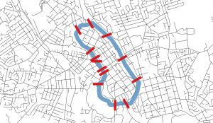
Another thing that stands out to me is the variation in the number of streets leading into the CBD. I drew a cordon around our four largest cities CBDs and counted the number of streets crossing them. I tried to draw the shape so that it captured the bulk of the CBD, but was also the most constrained area (fewest streets crossing it). All these maps are to the same scale – blue shows my central city outline, red shows each street that crosses it.


- Auckland has 16 streets leading into its CBD
- Wellington has 21 streets leading into its CBD
- Hamilton has 13 streets leading into its CBD
- Christchurch has 34 streets leading into its CBD
So Christchurch has the most, nearly twice as many as Auckland despite being a smaller CBD. It’s partly to do with where I’ve drawn my boundary, I could’ve maybe drawn it 1 or 2 blocks in from the 4 Avenues, but I think even then the point would still stand- Christchurch would still have the most.
Auckland is constrained mainly by the harbour to the north, and to a lesser extent, the motorway ring. Wellington is constrained by the harbour and hills. Although it has more streets into the CBD than Auckland, it’s important to note that the size of the populations that these service varies hugely, with many just servicing 1 or 2 suburbs, and then the single motorway to the north servicing over half the city. Hamilton is constrained by its two rivers and lake, although these are not too difficult to build additional crossings over if it was required. Christchurch CBD is constrained only by Hagley Park, and this shows in the much higher number of streets servicing its CBD. Also Christchurch’s corridors are all similar size – 27 of them are 2-way 2-lane streets, and of the 7 that aren’t, none are anywhere near the scale of the motorways that feed into the Auckland and Wellington CBD’s.
So both Auckland and Wellington have topographic constraints that channel vast populations (hundreds of thousands) into a small number of corridors. Christchurch on the other hand, has lots of little corridors that all serve only a few tens of thousands of people each. There are no locations here where populations in the scale of hundreds of thousands are channelled into a single transport corridor.
I suspect this is the main reason Auckland and Wellington both have high-capacity rapid transit, while Christchurch doesn’t. If everyone on the North Shore of Auckland tried to drive to the CBD they wouldn’t physically fit over the bridge – they need to get into buses to make it work. And if everyone in the Hutt Valley, Porirua and Kapiti Coast tried to drive to the Wellington CBD there is no way they would get close to fitting through the single corridor – they’ve had no choice but to develop trains and buses to get everyone through their bottlenecks.
In Christchurch there are no obvious bottlenecks like this, and so we haven’t had our decision made for us in the same way Auckland and Wellington have.
I thought I could fit all my thoughts on city shapes into 2 posts but I’ve already used 3 and I feel there’s still a lot more to be said on this. So I’ll stop here – next post I’m going to examine the larger Christchurch area more. So far I’ve focussed mainly on the contiguous parts of Christchurch city, but the satellite towns to the north and south are growing rapidly, and could potentially stretch the shape of the city into less of a circle and more of a swollen banana. More on that later – what are your thoughts on the shapes of NZ’s different cities?

Good post. I think the next one should be interesting too. If you put the natural boundaries for Christchurch’s contiguous growth being -Sea, Port Hill’s, Liquefaction area to the north, Waimakariri river, airport noise zone, unconfined aquifers to the west between Waimak river and West Coast road.
LikeLike
Yes I think once you’re out further then the natural constraints start to kick in much more strongly.
LikeLike
Also this show from a transport perspective what a stupid idea it was to move the University west to Ilam. Given that westward from the cbd is the direction with the least number of transport connections.
LikeLike
Universities in CBDs versus out in the wops is an interesting one though. I think it depends on the university, and whether it benefits from being close to everyone else, or whether it can just happily do it’s own thing in relative isolation.
LikeLike
It is strange how the general shift had been westward despite it being the only constrained direction. Partly better land, but not just that.
LikeLike
In a simplistic road sense yes, except that the west has the most concentrated bus corridor in the city and the busiest cycleway route as well (and quite a few additional cycling connections through Hagley Park not shown on your map). For a university, these connections are just as important as road ones.
LikeLike
Yea this ignores rail lines and walking and cycling paths. I wonder if Riccarton road developing into the busiest bus corridor and densest part our the city, and it being the only constrained route into the CBD, is no coincidence.
LikeLike
Also the compact and connected nature of Christchurch shows how many existing suburbs are close to the centre. Which would be ideal location to build more houses if only there was a mechanism to more easily do that.
Perhaps this is an opportunity for Hyperlocalism?
View at Medium.com
LikeLike
Yep agree. With extremely low densities we can get a fairly compact city. Even just getting our inner suburbs up to medium density would be a huge boost to housing stock.
LikeLike
Another intriguing comparison of our cities. I would be interested to know what the relative comparisons are when you add up the numbers of traffic lanes in and out of our central cities at these boundaries (ignoring additional intersection lanes). In Chch for example, I can only think of Riccarton Ave and Park Tce as having four lanes; virtually everything else has two. Meanwhile in Akld there are quite a few 4-lane entry points and a few with 6+ lanes as well (same to a slightly lesser degree in Wgtn as well).
LikeLike
Yea I started starting counting up lanes for Christchurch but it takes quite long. There were a few streets had 3 lanes, e.g. 2 traffic lanes plus a bus lane. And a couple that were one way roads.
LikeLike